


|
||

|

|
|

|
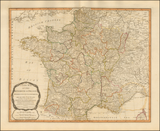
Fine original antique map showing the political divisions and Roman roads of ancient France, published in Paris in 1738 by Gilles Robert de Vaugondy.
The map shows France in detail with both its ancient and modern place names. Major Roman roads are indicated. Rivers, mountains, lakes, and more appear throughout.
The map includes a decorative cartouche in the lower left corner. In the upper right, the map describes the history of Gaul and its divisions under Roman rule.
The map extends into parts of Italy, Spain, Great Britain, German, and Switzerland.
Gilles Robert de Vaugondy (1688-1766) and Didier Robert de Vaugondy (1723-1786) were influential figures in the realm of 18th-century French cartography. Originating from Paris, their contributions to mapmaking were significant during an era of expansive geographical exploration.
Gilles Robert de Vaugondy entered the world of cartography not through family tradition but through personal interest and the budding opportunities of his time. Born in 1688, he worked during a time when Paris was becoming a central hub for cartographic activities. Gilles often incorporated the latest findings from explorers into his maps, making them sought-after for their contemporary relevance. His connections weren't limited to his immediate circle; he frequently interacted with other key mapmakers, staying updated on the latest techniques and findings.
His son, Didier, was born in 1723 and had the advantage of growing up surrounded by maps and globes. While his father was renowned for maps, Didier made a name for himself in the field of globemaking. His globes were some of the most precise and detailed in France, gaining recognition even among the royalty. In addition to his work in cartography and globemaking, Didier had a keen interest in education, especially after the expulsion of the Jesuits from France. He stepped in to produce geographical educational materials, fulfilling a newfound need.
The maps and globes produced by the Vaugondys remain an enduring testament to the peak of French cartography during the Enlightenment. Their works, characterized by precision and the inclusion of contemporary findings, helped to shape our understanding of the world during a transformative period in European history.
![[ France ] Galliae Regni Potentiss: Nova Descriptio Joanne Ioliveto Auctore . . .](https://storage.googleapis.com/raremaps/img/small/97834.jpg)
![Le Costa della Francia sul mare Oceano [The Coast of France on the Oceanic Sea]](https://storage.googleapis.com/raremaps/img/small/90844.jpg)
![[ Julius Caesar's Gaul ] Gallia vetus ex C. Julii Caesaris commentariis descripta, ex conatibus... 1649](https://storage.googleapis.com/raremaps/img/small/102569.jpg)