|
||

|

|
|

|
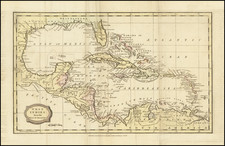
This antique map by Alain Manesson Mallet is a 17th-century French map of the American Southeast. It includes the towns of St. Mathieu and St. Augustin in Florida and labels "Canada ou Nouvelle France". A network of rivers on the map approximates what were the actual river systems of the south.
The map also features several different spellings of the Appalachian Mountains, highlighting the variation in naming conventions of the time. Overall, this map is a valuable artifact for studying the cartographic history of the region.
The map is based largely upon the earlier maps of Sanson and Du Val.
Alain Mannesson Mallet (1630-1706) was a French mapmaker and engineer who served in the armies of Louis XIV. After rising through the ranks, Mallet was appointed as Inspector of Fortifications, a job which also required mathematical skills and which made him a competent military engineer. Eventually, he joined the court of Louis XIV at Versailles, where he taught math and focused on writing.
Mallet is best known for his Description de L’Univers, first published in 1683, in five volumes. A wide-ranging geographical work, the Description included textual descriptions of the countries of the world, as well as maps of the celestial sky and the ancient and modern worlds. The Description continued to be published until the early eighteenth century. He also published a work in three volumes on warfare (1684) and a primer on geometry (1702).

![[Rare Blaeu West Indische Pascaert Wall Map Section] Insulae Americanae in Oceano Septentrionali, cum terris adjacentibus](https://storage.googleapis.com/raremaps/img/small/75672.jpg)
![[ Florida / Great Hurricane of 1926 ] West Hollywood After the Hurricane Sept. 1926](https://storage.googleapis.com/raremaps/img/small/101965.jpg)