|
||

|

|
|

|
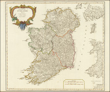
Decorative map of Ireland created by Thomas Kitchin, a prominent English cartographer and engraver, and was published in London in 1779.
The map covers the entire island of Ireland, from the northernmost point at Malin Head to the southernmost point at Mizen Head. It includes detailed information about the physical geography of the region, including the locations of mountains, rivers, lakes, and coastal features. The map offers an accurate depiction of these physical features, which were based on the latest scientific and cartographic knowledge of the time.
In addition to its geographical information, the map also includes a wealth of political and cultural information about Ireland in the late 18th century.
Thomas Kitchin was a British cartographer and engraver. Born in Southwark, England, Kitchin was the eldest of several children. He was apprenticed to the map engraver Emanuel Bowen from 1732 to 1739, and he married Bowen’s daughter, Sarah, in December 1739. By 1741 Kitchin was working independently and in 1746 he began taking on apprentices at his firm. His son Thomas Bowen Kitchin was apprenticed to him starting in 1754. By 1755 Kitchin was established in Holborn Hill, where his firm produced all kinds of engraved materials, including portraits and caricatures. He married his second wife, Jane, in 1762. Beginning in 1773 Kitchin was referred to as Hydrographer to the King, a position his son also later held. He retired to St. Albans and continued making maps until the end of his life.
A prolific engraver known for his technical facility, clean lettering, and impressive etched decorations, Kitchin produced several important works throughout his career. He produced John Elphinstone’s map of Scotland in 1746, and the first pocket atlas of Scotland, Geographia Scotiae, in 1748/1749. He co-published The Small English Atlas in 1749 with another of Bowen’s apprentices, Thomas Jefferys. He produced The Large English Atlas serially with Emanuel Bowen from 1749 to 1760. The latter was the most important county atlas since the Elizabethan era, and the first real attempt to cover the whole country at a large scale. In 1755 Kitchin engraved the important John Mitchell map of North America, which was used at the peace treaties of Paris and Versailles. In 1770 he produced the twelve-sheet road map England and Wales and in 1769–70 he produced Bernhard Ratzer’s plans of New York. In 1783, he published The Traveller’s Guide through England and Wales.
![[ Ireland ] Hyberniae Regni in Provincias Ultoniam, Connachiam, Lageniam, Momoniamq divisi Tabula Accuratisima editore Covens et Mortier Amstelo-Batavio](https://storage.googleapis.com/raremaps/img/small/99667.jpg)
![Ireland in Provinces and Counties [with] County Map of Scotland](https://storage.googleapis.com/raremaps/img/small/78014.jpg)
![[ World Atlas ] Geography Anatomized: or, A Compleat Geographical Grammer. Being a Short and Exact Analysis of the whole Body of Modern Geography... To which is subjoin'd the present State of the European Plantations in the East and West Indies, with a Reasonable Proposal for the Propagation of the Blessed Gospel in all Pagan Countries.](https://storage.googleapis.com/raremaps/img/small/85550.jpg)