|
||

|

|
|

|
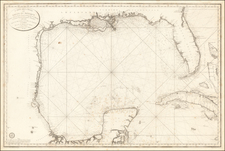
This map is a rare variant of Jacques Nicolas Bellin's map normally titled "Carte De La Louisiane et Pays Voisins." In this variant edition, the title includes the name "Floride" in the title.
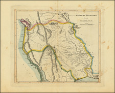
This map provides detailed information about the interior of the present-day United States on either side of the Mississippi River. It is based on De L'Isle's folio map of the region, and it includes information about early French forts and other settlements. The map also shows the exploration and settlement of the region west of the Mississippi, including forts, Native American villages, and other place names.
One of the key features of the map is its depiction of the unknown region in northern Texas and the Native American territories between the Mississippi and the Rio Grande. This area was not well understood by Europeans at the time, and the map provides valuable information about the first settlements in this region along the Gulf Coast and in the interior of Texas. The map also shows the courses of a number of rivers, including the Mississippi, providing valuable information for travelers and explorers. Overall, this is a fascinating and historically significant map of the Mississippi River Valley and its surrounding areas.
Jacques-Nicolas Bellin (1703-1772) was among the most important mapmakers of the eighteenth century. In 1721, at only the age of 18, he was appointed Hydrographer to the French Navy. In August 1741, he became the first Ingénieur de la Marine of the Dépôt des cartes et plans de la Marine (the French Hydrographic Office) and was named Official Hydrographer of the French King.
During his term as Official Hydrographer, the Dépôt was the one of the most active centers for the production of sea charts and maps in Europe. Their output included a folio-format sea atlas of France, the Neptune Francois. He also produced a number of sea atlases of the world, including the Atlas Maritime and the Hydrographie Francaise. These gained fame and distinction all over Europe and were republished throughout the eighteenth and even in the nineteenth century.
Bellin also produced smaller format maps such as the 1764 Petit Atlas Maritime, containing 580 finely-detailed charts. He also contributed a number of maps for the 15-volume Histoire Generale des Voyages of Antoine François Prévost.
Bellin set a very high standard of workmanship and accuracy, cementing France's leading role in European cartography and geography during this period. Many of his maps were copied by other mapmakers across the continent.