


|
||

|

|
|

|
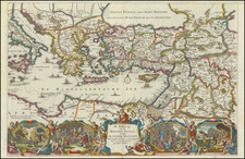
This antique map of the eastern part of the Roman Empire, published by Henri Chatelain at the beginning of the 18th century, provides a fascinating look at the region during a significant period in its history. The map covers a large area, extending from Greece in the west to India in the east, and it includes the Persian Gulf, the Caspian Sea, and the Black Sea.
The map includes a detailed history of the region from the first Roman Emperors up to Theodosius the Great in 395 AD. It is beautifully illustrated and hand-colored, with a detailed depiction of the various provinces and their boundaries. Major cities, rivers, and other important features are also labeled, providing a rich and comprehensive view of the Eastern Roman Empire.
Overall, the map is an excellent example of 18th-century cartographic techniques, and it offers a valuable glimpse into the history of the eastern Roman Empire. It is a valuable piece for any collector of antique maps or anyone interested in the history of the region.
Henri Abraham Chatelain (1684-1743) was a Huguenot pastor of Parisian origins. Chatelain proved a successful businessman, creating lucrative networks in London, The Hague, and then Amsterdam. He is most well known for the Atlas Historique, published in seven volumes between 1705 and 1720. This encyclopedic work was devoted to the history and genealogy of the continents, discussing such topics as geography, cosmography, topography, heraldry, and ethnography. Published thanks to a partnership between Henri, his father, Zacharie, and his younger brother, also Zacharie, the text was contributed to by Nicolas Gueudeville, a French geographer. The maps were by Henri, largely after the work of Guillaume Delisle, and they offered the general reader a window into the emerging world of the eighteenth century.
![[The Travels of Paul] Tabula Geographica, in qua omnes regiones, urbes, oppida, et loca describuntur, quorum mentio fit in Actis et Epistolis Apostolotum, et Apocalypsi; de integro multis in locis emendata, ac regionum limitibus distincta, auct. Pet. Planc. . . .](https://storage.googleapis.com/raremaps/img/small/77970.jpg)
![An Account of the Kingdom of Caubul, and its Dependencies in Persia, Tartary, and India; Comprising a View of the Afghaun Nation, and a History of the Dooraunee Monarchy [with map:] A Map of the Kingdom of Caubul, and some of the Neighbouring Countries](https://storage.googleapis.com/raremaps/img/small/89552.jpg)