|
||

|

|
|

|
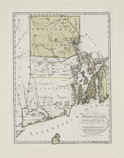
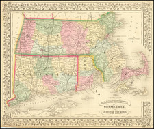
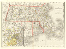
Finely engraved rare large format map of Rhode Island produced by Daniel Friedrich Sotzmann for Christopher Ebeling's Erdbeschreibung von Amerika.
Sotzmann's map captures all of Rhode Island, including Block Island off the southern coast in remarkable detail. Great attention is given to the physical geography of the state, including lakes, rivers and streams; areas of elevation and hydrographic data. County and township boundaries illustrated using differing styles of dotted lines. with roads shown and street plans given for Providence, Bristol, Wickford and Newport; as well as individual buildings in less densely populated areas.
The map is a compilation of the best available sources, a tribute to Ebeling’s tireless correspondence. Two primary sources include Charles Blaskowitz’ Topographical Chart of the Bay of Narragansett (1777) and Caleb Harris’ Map of the State of Rhode Island (1795).
Ebeling was a German who undertook and exhaustive study of America, which became a serial publication. After studying the work of a number of engravers he selected Sotzmann to engrave a set of maps of the states of the United States. Unfortunately, due to an extended illness, Ebeling did not finish the project and only 10 of the maps were published.
Walter Ristow states that only a handful of North American institutions have examples of all ten maps, making the series among the rarest cartographic Americana for the closing decade of the 18th Century.
The state maps that were completed were among the best available at the time in terms of scale and level of detail. The map provides excellent topographical and political detail, including land holdings of several individuals. Shows meeting houses, shipyards, soundings, ponds, and a host of other details.
An essential map for Rhode Island and New England collectors.