|
||

|

|
|

|
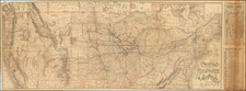
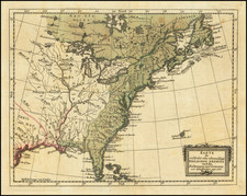
One of the Earliest Wall Maps of the United States Published In America
Rare separately published example of this important 4-sheet wall map of the United States by Samuel Lewis, "Engraved for and Sold By Matthew Carey, Philadelphia."
This remarkable 4 sheet map was the most widely published map of the United States in the 1790s, providing Americans for the first time with a detailed visual understanding of the extent of the United States claims to the Mississippi River. Beyond the Mississippi is Spanish Louisiana Territory, prior to of the Louisiana Purchase and the Third Treaty of San Ildefonso, wherein Napoleon secretly acquired the territory, but Spain continued to administer it, until the Louisiana purchase in 1803.
The detail along the Ohio River is of particular note, at a time when real estate speculation in the region was strong, including American land speculators and significant French investment during the early years following the French Revolution. The "Northwest Territory" is shown, predating the appearance of Ohio (statehood granted on February 19, 1803), Indiana Territory (created May 7, 1800), Illinois Territory, and Michigan Territory (created June 30, 1805). The detail along the River includes a number of early forts, including Fort Pitt, Fort Washington, Harden's Fort, Fort Massac and Fort Johnston, as well as early settlements, such as Wheeling, Marietta, Bellepre, Gallipolis, Charleston, Washington, Columbia, Louisville, Clarkville, and an unnamed settlement in Illinois.
In the south, a massive Georgia is shown, still extending to the Mississippi River and pre-dating the creation of Mississippi Territory on April 7, 1798. No American settlements in the future states of Alabama and Mississippi are very sparse, with only Mobile (still in Spanish West Florida) shown. Many Native American settlements are shown. The furthest western settlements in Georgia would seem to be Fort Fidius (constructed in 1790 under the Treaty of New York and abandoned by the Americans in 1797 in favor of Fort Wilkinson, on the west side of the river) and Gorham's Fort, along with a few settlements on the upper forks of the Ogeechee River, including Louisville, Waynesborough and Old Town.
The large inset map of Florida, then Spanish East and West Florida, is likely the first "separate" map of Florida published in America. Extending west to New Orleans and north to the St. Mary's River, the map provides a detailed treatment of Florida, including a number of British names for the islands at the southern tip of the Florida Keys, including Fitzherbert Island, Newcastle, Richmond Bay. The earlier candidate, Bernard Roman's 2 large maps of East and West Florida, is broken into two maps (and essentially unobtainable).
The Lewis map is one of only 5 multi-sheet maps of the United States printed in America prior to 1800. The other 4 (Abel Buell, Osgood Carleton, Abraham Bradley and William MacMurray) are essentially unobtainable.
The first state of Lewis' map incorporates for the first time on a large format map of the United States the newly created Territory of "Tennasee" (which would become a state on June 1, 1796) and Kentucky (which had become a state on June 1, 1792), along with a reasonable well-configured treatment of the District of Maine, which would not become a state until 1820.
Rarity & State
All states of Carey's map of the United States are rare on the market.
This example is state 3 (of 6), after the additional engraving in the Chesapeake Bay but before the addition of "24" to the upper-left corner.
![[ Florida Indians - King Outina Consulting a Sorcerer ] Outina adversus hostem exercitum ducens, de eventu Magum consulit. XII.](https://storage.googleapis.com/raremaps/img/small/97101.jpg)