|
||

|

|
|

|
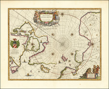
"Important map for navigation in the Polar Regions" (Frederik Muller)
Striking example of Ottens 2-sheet map of the region from Hudson Bay, Baffin Bay, Button Bay, Davis Straits and contiguous parts of the coastline of Canada and Greenland to Nova Zembla.
Fine example of this remarkable two sheet map centered on Greenland, Iceland and the North Atlantic, teasing the prospects of both a northwest and northeast passage in the middle of the 18th Century. At the far west, in Baffin's Bay, Button's Bay and Hudson's Bay, several openings to the west suggest the prospects of a passage further west by water. At the far east, the waters above Nova Zembla remain open for exploration. The polar coastlines of Greenland are largely unexplored, with a large and mostly conjectural Cumberland Island corresponding to Baffin Island shown, along with a thinly explored Hudson's Strait and Davis Strait.
In the center of the North Atlantic below the compass rose, a reference to a sunken island remains, both a remnant of the many mythical islands which appeared on maps of these waters in the 15th, 16th and 17th centuries and likely a nod to the mythical Atlantis.
The map was issued at a moment in time when the dispute centered on Arthur Dobbs and Christopher Middleton was nearing its height, following the 1741 Northwest Passage Expedition and pre-dating the 1746 expedition, at at time when the two were in dramatic conflict over the exploration of the region, prospects for a Northwest Passage and the continuing proprietary rights and claims of the Hudson's Bay Company.
The present example is the third state of the map, and is part of a series of charts of the region that began with Van Loon's map of 1668. The basic template remained Hessel Gerritz's printed version of Henry Hudson's charts, published in Amsterdam in 1612. Over time the cartography was improved by Jansson, Blaeu and Sanson, from which the present depiction has been composed. Frederick De Wit (1630-1706) was by the time this chart was published the leading Dutch mapmaker. His chart came out at a critical juncture, for in 1670, the English had founded the Hudson's Bay Company, which would dominate commerce in the region for the next 250 years. De Wit's map remained the authoritative printed chart of these subarctic waters for the remainder of the century.
The composition is traversed with rhumblines and is embellished with two allegorical cartouches, while a pair of ships fight a battle in the Davis Strait.
While these maps are often found as separate atlas sheets, it is unusual to seem the joined as a single sea chart.
In its 1910 catalog Geographie, voyages--Amerique, Afrique, Australie, Russie, Indes orientales, Chine, Japon, Régions polaires, Marine, etc, #3593, the famed dealer Frederik Muller & Cie. described the map as:
Carte importante pour la navigation au Regions Polaires, designant les cotes et les detroits de l'Amerique septentrionale, Groenland et Spitsburgen, et les cotes de l'Europe.
Translation: Important map for navigation in the Polar Regions, designating the coasts and straits of North America, Greenland and Spitsburgen, and the coasts of Europe.
Rarity
This is the first time we have offered the map for sale as a joined pairing.
The Ottens brothers, Reiner and Joshua, operated a successful printing partnership in the mid-eighteenth century (fl. 1726-1765). They began the venture in 1726, publishing maps and other prints as “R & I Ottens.” They specialized in the reprinting of others’ work, especially Guillaume De L’Isle. In 1750, Reiner died; his soon, also Reiner, took his place, but the firm began listing their works as “Joshua & Reiner Ottens.” The firm lasted until Joshua’s death in 1765. Joshua’s widow, Johanna de Lindt, sold their remaining stock of plates in 1784.
![[ Atlantic Ocean / Triangular Trade / Negroland ]](https://storage.googleapis.com/raremaps/img/small/65187.jpg)