


|
||

|

|
|

|
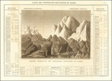
This antique Russian-language map showcases the relative heights of mountains across the world, separated by continent. Depicting the eastern hemisphere in the upper left corner and the western hemisphere in the upper right corner, the map presents a unique perspective of the world's peaks. The map's text is in Russian, which is unusual for such a representation during this time period.
Published around 1890 by Friedrich Arnold Brockhaus in Leipzig, this map stands out due to its Russian-language descriptions and focus on the heights of mountains across different continents. By organizing the peaks geographically, the map emphasizes the varying topography found throughout the world and invites viewers to explore the unique features of each region.
This distinctive map offers a fascinating look into the world's mountains, highlighting the majestic peaks that span across continents. By showcasing the relative heights of these natural wonders, the map allows viewers to appreciate the diverse landscapes and geological formations that make up our planet.
![Comparative Size of Lakes and Islands [Great Lakes, Cuba, Formosa, Ireland, Sicily, Cyprus, Vancouver, Sandwich Islands, Puerto Rico, Corsica, Sardinia, Balearics, Malta, etc]](https://storage.googleapis.com/raremaps/img/small/100135.jpg)
![Comparative Size of Lakes and Islands [Great Lakes, Cuba, Formosa, Ireland, Sicily, Cyprus, Vancouver, Sandwich Islands, Puerto Rico, Corsica, Sardinia, Balearics, Malta, etc]](https://storage.googleapis.com/raremaps/img/small/92574.jpg)