|
||

|

|
|

|
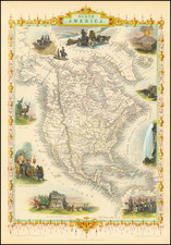
This antique map of North America is a scarce Russian-language mapping of the continent. Published in Leipzig by Friedrich Arnold Brockhaus around 1890, the map is written in Russian, which is unusual for maps of this region and time period.
The main image of the map shows the political boundaries of North America, with borders shown and labels written in Russian. The inset map of the eastern United States is shown in more detail, allowing for a closer look at the individual states and their borders.
The borders of the map are filled with vignette illustrations, adding a powerful visual element to the map. These illustrations include five western scenes, such as one of a stampede of buffalo, adding a sense of the vastness and wildness of the region. There is also an illustration of the U.S. Capitol Building, highlighting the political and cultural significance of the United States.
Overall, this map is a valuable piece for any collector of antique maps or anyone interested in the political history of North America. Its Russian text and detailed illustrations make it a unusual and fascinating artifact.
![[First State of the Popple Key Sheet] A Map of the British Empire in America with the French and Spanish Settlements adjacent thereto by Hen. Popple.](https://storage.googleapis.com/raremaps/img/small/92714.jpg)