The item illustrated and described below is sold, but we
have another example in stock. To view the example which
is currently being offered for sale, click the
"View Details" button below.
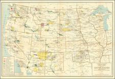
1927 United States Department of the Interior
$ 275.00


|
||

|

|
|

|
Stock# 90246
Description
Interesting original vintage map of the lands managed by the Department of the Interior west of the Mississippi in 1924.
This map shows National Parks, National Monuments, reclamation projects, and a wide variety of other Department lands, offices, and managed areas. Roads and rivers are also shown. The map shows Craters of the Moon National Monument, which had just been founded in 1924. Also founded that year were Castillo de San Marcos, Chiricahua, Fort Matanzas, Fort Pulaski, and Wupatki.
This map was compiled by M. Hendges and revised by J. J. Black under the direction of I. P. Berthrong. The map was engraved and printed by the USGS.
Condition Description
Folding map. Minor fold toning.
![[ US-Mexico Border Survey: General Order From the President of the United States Directing William H. Emory to lead the US-Mexico Boundary Survey ]](https://storage.googleapis.com/raremaps/img/small/101837.jpg)
![[ First Map to Name The United States ] L'Amerique septentrionale ou se remarquent les Etats Unis . . . 1779](https://storage.googleapis.com/raremaps/img/small/94192.jpg)
![[ Massive Misplace Idaho Territory ] The United States of North America.](https://storage.googleapis.com/raremaps/img/small/99361.jpg)