|
||

|

|
|

|
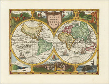
Early Jodocus Hondius-Engraved World Map. Rare First State. "Copies with the original date of 1602 are rare." - Shirley 233
Rare double-hemisphere map of the world, engraved by Jodocus Hondius and published by in Paris by Jean Le Clerc.
The map is one of several maps engraved by Hondius which survive only in examples published in 1602 and thereafter by Le Clerc, including a second world map, a set of 4 continental maps and a map of England. The map of America is dated 1589. This world map and the map of America have fascinating scholars for nearly a century, both for their remarkable content which can only be ascribed to a contemporary knowledge of the voyage of Sir Francis Drake and the mysterious path travelled by the copperplates from Hondius to Le Clerc in Paris.
The present map is modeled after Gerard Mercator's world map of 1587, but with one remarkable difference, the inclusion information from Sir Francis Drake's circumnavigation in the area south Tierra del Fuego. Here Hondius clearly refers to Drake with the note: "Insulae Reginae Elisabethae (The Islands of Queen Elizabeth). This is a reference to islands which Drake believed he had discovered in 1589, and which are known to appear only on the Hondius-Le Clerc maps and on several extremely rare maps directly attributed Drake (and engraved by Hondius during his time in England between 1584 and 1593), discoveries which the English worked diligently to conceal, as it would show both a breach of the heavily guarded Spanish control of the passage from the Atlantic to the Pacific and reveal the existence of open seas south of Tierra del Fuego, a passage which would not be formally "discovered" until Le Maire and Schoten's voyage of 1617 formally announced this southerly route.
Jodocus Hondius as the Map Engraver
Jodocus Hondius was resident in London from 1584 to 1593. During this time, it is well known that Hondius had contacts with Sir Walter Raleigh, John Smith and Francis Drake among other English explorers and mapmakers. Toward the end of his time in London, Hondius engraved the gores for the Molyneaux Globes, as well as his small world map (Typus Orbis Terrarum) of 1589, which shows both the route of Drake's circumnavigation and the islands and open water south of Tierra del Fuego. The same details also appear on his later "broadside" map dated 1589, but believed to have been engraved in the early 1590s.
While the map has been described by some as having been re-engraved by Le Clerc, the evidence to suggest that the map was not originally engraved by Jodocus Hondius in London is circumstantial. Most recent scholars have concluded that this map is in fact the work of Hondius in London. Most recently, Gunter Schilder makes the case for London in Monumenta Cartographica Neerlandica Vol. 8 (2007).
It should also be noted that while Le Clerc was active as an printer and engraver in Paris in 1602, there appear to be no extent maps actually engraved by Le Clerc until 1617, other than the 2 world maps, 4 continents and map of England, all of which are dated between 1602 and 1605. Le Clerc and his cohort of French printers and engravers in this period are known to have had contact with Hondius prior to his departure from London. At least one modern scholar has opined in correspondence with this firm that Hondius likely sold the plates shortly after 1600 in anticipation of buying the Mercator atlas copper plates, and, in fact, a number of other plates attributed to Hondius began to circulate in France with other engravers and printers shortly after 1600.
Francis Drake Information via Jodocus Hondius
The map is most noteworthy for its identification of Sir Francis Drake's theories of Islands off the south coast of South America, 15 years before its actual discovery. The present map does not show the "Estrecho di Magellanes" as a narrow strait between two continents, but instead shows a large group of islands, including the "Insulae Reginae Elisabetae" (Islands of Queen Elizabeth), the names used by Drake. All other maps of the period showed the straits of Magellan as the only navigable watercourse from the Atlantic to the Pacific, with a massive southern continent below the Strait. The path around the Horn was critical to European powers eager to circumvent Dutch claims of control over the Strait and therefore access from the Atlantic to the Pacific.
Hondius no only includes the islands of Queen Elizabeth off the tip of South America, he also notes that Nova Albion on the far west of cost of North America was so named by the English in 1580.
According to Norman Thrower, the plates were likely engraved by Jodocus Hondius between the two Drake reports
Although the map was probably initially prepared in England, it was never given a privilege there (almost certainly because of the sensitive Drake content), and so Hondius was forced to sell it to someone in France who would have been free to print it.
A panel at the bottom contains a quote from the Psalms which was one of Hondius' favorites. The upper corners include circles showing the wind names in Italian and Dutch. The lower corners have circular diagrams showing the phases of the moon and the climatic zones. An astronomical sphere and compass rose are also included. Wonderful large unknown southern continent, narrow passage between South America and the unknown continent, excellent treatment of Japan and Southeast Asia and marvelous early cartography in the Pacific Ocean and along the Northwest Coast of America.
Rarity
Shirley notes that examples of the map bearing the original 1602 date are very rare. This is one of the earliest obtainable world maps published in Paris.
Jodocus Hondius the Elder (1563-1612), or Joost de Hondt, was one of the most prominent geographers and engravers of his time. His work did much to establish Amsterdam as the center of cartographic publishing in the seventeenth century. Born in Wakken but raised in Ghent, the young Jodocus worked as an engraver, instrument maker, and globe maker.
Hondius moved to London in 1584, fleeing religious persecution in Flanders. There, he worked for Richard Hakluyt and Edward Wright, among others. Hondius also engraved the globe gores for Emery Molyneux’s pair of globes in 1592; Wright plotted the coastlines. His engraving and nautical painting skills introduced him to an elite group of geographic knowledge seekers and producers, including the navigators Drake, Thomas Cavendish, and Walter Raleigh, as well as engravers like Theodor De Bry and Augustine Ryther. This network gave Hondius access to manuscript charts and descriptions which he then translated into engraved maps.
In 1593 Hondius returned to Amsterdam, where he lived for the rest of his life. Hondius worked in partnership with Cornelis Claesz, a publisher, and maintained his ties to contacts in Europe and England. For example, from 1605 to 1610, Hondius engraved the plates for John Speed’s Theatre of the Empire of Great Britaine.
One of Hondius’ most successful commercial ventures was the reprinting of Mercator’s atlas. When he acquired the Mercator plates, he added 36 maps, many engraved by him, and released the atlas under Mercator’s name, helping to solidify Mercator’s reputation posthumously. Hondius died in 1612, at only 48 years of age, after which time his son of the same name and another son, Henricus, took over the business, including the reissuing of the Mercator atlas. After 1633, Hondius the Elder’s son-in-law, Johannes Janssonius, was also listed as a co-publisher for the atlas.
Jean Le Clerc was an engraver, bookseller and publisher in Paris and Tours.
Le Clerc was baptized on August 16, 1560 in Paris, with the engraver François Desprez (1530–1587) and the painter Jérôme Bollery (1532–1592) as his godfathers. He came from a family of printers and publishers - Jean's younger brother David Le Clerc (1561–1613) and Jean's own son Jean Le Clerc V were both book printers and publishers.
He had proved himself by 1587, at which date he was living and working on Rue Chartière in Paris. For religous reasons, as a Huguenot he fled Paris in 1588 and spent a year elsewhere in France. From 1590 to 1594 he took refuge in Tours, where he worked with the publisher and cartographer Maurice Bouguereau (15??–1596), who created Le Theatre Francoys, the first atlas of France. Le Clerc later worked at several different addresses in Paris - on Rue Saint-Jean-de-Latran until 1610 and then on Rue Saint-Jacques until 1621/24.
Jean Le Clerc's publications included portraits, maps, contemporary news events and other engravings by Jacques Granthomme (1560–1613), Pierre Firens (1580–1636) and Léonard Gaultier (1561–1635). He collaborated with the Dutch printmaker Thomas de Leu (1560–1612) to produce a collection of 179 biblical scenes, allegories, calendar pages and other works, probably published in 1606. They both produced engravings for it themselves as well as using works by Justus Sadeler (1580–1620), Isaac Briot (1585–1670) and Nicolas Briot (1579–1646).
On December 20, 1619 Le Clerc was granted a six-year royal concession to "engrave maps of the provinces of France and portraits of patriarchs and princes of the Hebrew people, with a chronological history". In 1620 he published his Le Théâtre géographique du Royaume de France, including newer plates as well as reworked plates from Bouguereau's work. The new plates were produced by artists such as Jean Fayen (1530–1616), Jodocus Hondius (1563–1612), Salomon Rogiers (1592–1640) and Hugues Picart (1587–1664). It went through several editions and Jean Le Clerc V continued to reissue it after his father's death.

![[Tasman Discoveries]. Orbis Terrarum Typus De Integro In Plurimis Emendatus Auctus, Et Icunculis Illustratus](https://storage.googleapis.com/raremaps/img/small/83872.jpg)