|
||

|

|
|

|
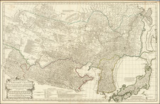
Du Halde's map of Korea is a landmark in the mapping of Korea and the first map to provide a reasonable accurate mapping of the Peninsula. In the early 18th Century, the Jesuit Missionaries were finally able to gain access to the indigenous cartography of Korea in an indirect fashion. Since the Jesuits were not actually allowed into Korea the Tartar Lord (Mukedeng, a troubleshooter and trusted assistant for the Kangxi emperor) was accompanied a Chinese Sureyor trained by the Jesuits. While closely monitored, they were allowed to produce a map which was exported to the Jesuits through the Tartar Lord. The map was produced by Jean-Baptiste Regis produced and was used and edited by d'Anville and published in 1735 in du Halde's English edition of his Atlase of China and later in 1737 in the French edition. Du Halde was a French Jesuit, and geographer of Paris. The map remained the most important and influential mapping of Korea for the next century or more. Offered here in a fine wide margined example, with a tiny bit of offsetting. No example of the French edition of the map has appared in the past 20 years.
![[ Game Board World Map -- Gulf of Korea named ] Walker's Geographical Pastime Exhibiting a Complete Voyage Round the World in Two Hemisphere with Tetotum, Pillars & Counters, for Playing This Highly Interesting Game.](https://storage.googleapis.com/raremaps/img/small/102691.jpg)
![[ Japan and East Coast of Korea ] Charte Der Iapanischen Inseln . . . 1811](https://storage.googleapis.com/raremaps/img/small/97099.jpg)