This item has been sold, but you can enter your email address to be notified if another example becomes available.


|
||

|

|
|

|
Stock# 90144
Description
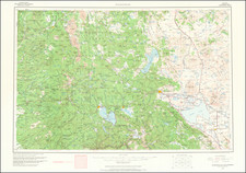
Fine, computer-produced elevation and land-use map of California, showing the topography and diversity of the nation's most populous state.
The map includes some thirty types of land indications, as well as various other symbols and denotations. Elevation appears to be shown using the darkness of the image, although this is not fully clear.
This map was published by the now-defunct www.geowaremaps.com and credits John Crews as the creator.