|
||

|

|
|

|
Stock# 90101
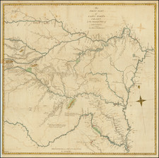
Description
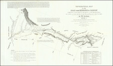
Detailed map of the northern part of Nebraska and southern part of South Dakota, providing an overview of the military encampments and Native American settlements in Dawes County and Sheridan County, Nebraska, focused on the Pine Ridge Agency.
The map illustrates the area of conflict in the final part of American conflicts with the Ogallala and Lakota Sioux Nations.
The Pine River Agency is ringed by U.S. military regiments, with the Big Foot Battle of December 29, 1890 shown at the upper right. Known more commonly as the Wounded Knee Massacre, this is the location where nearly 300 Lakota killed by the 7th Cavalry Regiment, under teh command of Colonel James W. Forsyth, two weeks after the Sitting Bull killed.
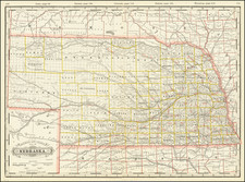
![Rand, McNally & Co's Nebraska [Rand, McNally & Co's Indexed Township and County Pocket Map and Shippers' Guide of Nebraska]](https://storage.googleapis.com/raremaps/img/small/85065.jpg)