
This item has been sold, but you can enter your email address to be notified if another example becomes available.


|
||

|

|
|

|
Stock# 90100
Description
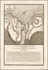
Rare 1850 engraving of the Guy Johnson manuscript map of the lands controlled by the Six Nations on the eve of the American Revolution.
The map shows the region between Lake Ontario and Lake Eerie to the west and the "Katts Kill Mountains" and "Massachussets Bay" to the east. Notes reveal the earliest colonial idea of what the region actually had in store, and the original manuscript map was based on the reports of traders and Native Americans. Notes are made about the various tribes living in the area.
This map was issued in the Documentary History of the State of New York and published in 1850.
Condition Description
Toning and some foxing.

![(New York-Robert C. Livington) [Revolutionary-Era Land Indenture]](https://storage.googleapis.com/raremaps/img/small/91957.jpg)
![Map of the State of New York with Part of Upper Canada [Large inset plan of New York]](https://storage.googleapis.com/raremaps/img/small/91848.jpg)
![(New York - Long Island) Topographical Maps Long Island [Cover Title]](https://storage.googleapis.com/raremaps/img/small/88766.jpg)