|
||

|

|
|

|
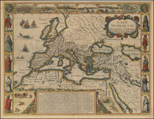
Rare historical map of Europe during the reign of Louis the Pious, published in Jean Marie Frantin's Louis-le-Pieux et son siècle in 1839. The map shows Europe in its entirety with its various tribes and proto-nation states.
Louis the Pious was the King of the Franks from 814 to 840 and the son of Charlemagne. He was known for his piety and his willingness to work for the betterment of his people. During his reign, Louis implemented a number of administrative and economic reforms that helped to strengthen the Frankish Kingdom and improve the lives of its people. He also worked to spread Christianity throughout his kingdom, and supported the growth of monasticism.
During Louis's reign, Europe was divided into a number of different tribes and kingdoms. Some of the major tribes and kingdoms that existed in Europe during this time included the Franks, the Saxons, the Visigoths, and the Vikings. The aforementioned Frankish Kingdom, which was ruled by Louis the Pious, was located in what is now modern-day France and Germany. The Saxons were located in what is now Germany (Germania), while the Visigoths were located in what is now Spain (Hispania). The Vikings were located in what is now Scandinavia (Dania).
![[ Eastern Hemisphere Globe Gores. ] (Nova et integra universi Orbis descriptio)](https://storage.googleapis.com/raremaps/img/small/54480.jpg)
![[Roman Europe] Patriarchatus Romanus . . . .](https://storage.googleapis.com/raremaps/img/small/85235.jpg)