|
||

|

|
|

|
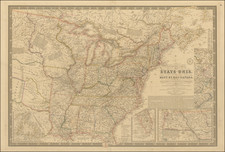
Extremely Rare Jacob Monk Wall Map Focusing on Prospective Transcontinental Railroad Routes.
In this very rare 1856 wall map of North America, the prolific American wall map publisher Jacob Monk turned his attention to two emergent revolutions in transportation and communications: long-distance telegraph lines and transcontinental railroads.
The Pacific Railroad Surveys, which sought suitable routes for railroads across the American West, were conducted between 1853 and 1855. With the conclusion of the surveys in '55, much excitement about the possible future of transcontinental railroads followed in 1856. Monk's map capitalizes on that interest by depicting six proposed routes, accompanying them with illustrations of locomotives so their meaning could not be missed. Monk depicts the following routes (south to north):
- [Proposed Route from Texas to San Diego and Los Angeles]
- [Proposed Route from St. Louis to Los Angeles]
- Proposed Rail Road from Westport to San Francisco 2080 miles
- Proposed Rail Road from Council Bluffs to Benicia California 2030 miles
- Proposed Rail Road from Council Bluffs to Benicia California [North Fork Platte River Route]
- Proposed Rail Road from St. Paul to Vancouver 1864 miles
It would take another 13 years for the first transcontinental railroad to finally be completed, but this map stands as an important visual monument to the public feeling of excitement and possibility that marked the real beginning of the transcontinental project.
The first transcontinental telegraph beat the first transcontinental railroad by 8 years, having been completed in 1861. However, on this map, the primary focus is on the web of telegraph lines spreading across the eastern U.S. This is important and somewhat novel information in itself and is worthy of further study.
This Map in the Context of Other Monk Wall Maps
Monk's Rail Road & Telegraph Map was issued between the early-1850s New Map of that Portion of North America and the late-1850s Monk's Standard American Map. The latter map seems to be partially based on the Rail Road & Telegraph Map through a transfer lithographic process.
The present map was issued only in 1856, whereas Monk's Standard American Map was issued first in '56 and then at least in '58, '59, and '61. Monk's New Map of that Portion of North America was issued in 1851, 1852, 1853 (two states), 1854 (again two states), 1856, 1857, and 1858.
Rarity
No copies are located in RBH. OldMaps.com lists one sale, on eBay, in 2001. Not in the Rumsey Collection. OCLC locates examples only at Cornell University and Brown University.
![[An English Propaganda Map In French] Carte Des Possessions Angloises & Francoises Du Continent De L'Amerique Septentrionale 1755.](https://storage.googleapis.com/raremaps/img/small/86975.jpg)