|
||

|

|
|

|
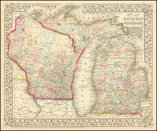
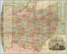
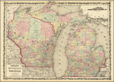
Separately published example of this rare map of Ohio and southeastern Michigan (then the "Settled Part of Michigan") published by Anthony Finley in 1830.
The map is of particular relevance for its timely focus on the relationship between Michigan and Ohio, which would shortly boil over into the "Toldeo War". The cause of that conflict was the strange jog of the border between the Territory of Michigan and the State of Ohio, which is well illustrated on this map. The conflict lasted from 1835 to 1836 and resulted in only one casualty; Deputy Sheriff Joseph Wood from Michigan received non-life-threatening stab wounds after having gone to Toledo to arrest an Ohioan.
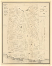
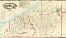
The map shows travel routes, canals, towns, rivers, railroads, etc. A profile of the Ohio and Erie Canal is included at the bottom of the map. Only 18 Michigan counties are shown, four years before statehood. Although some detail is shown in Michigan's Sanilac county is void of detail.
Rarity & Editions
This map only appeared in the very late editions of Finley's New General Atlas, after Finley had sold much of his business to Mitchell, and is therefore rare on the market.
This is only the second time that we have had this map. Before this, we concluded that only one copy had appeared in a dealer catalog in the past 30 years (High Ridge, 1992).
We are aware of at least four states of the map:
- 1830: Separately published
- 1833. So-dated in the title.
- 1834. With the title date advanced to 1834.
- 1836? Lacking a title date and with the "Boundary Claimed by Ohio" added, and the southern boundary now labeled "Boundary Claimed by Michigan". See Rumsey 13379.
Anthony Finley (1784-1836) was an American map publisher. Little is known about his life. He is presumed to have been born in Philadelphia, where he also died. A publisher, Finley was also involved in several Philadelphia civic and professional societies such as the Philadelphia Apprentices’ Library. He may have been in business as early as 1809 and his first publication dates from ca. 1811.
His first maps also date from this year, with two maps in Daniel Edward Clarke’s Travels in Various Countries of Europe, Asia, and Africa. The first atlas published by Finley appeared in 1818, the Atlas classica, or, Select maps of ancient geography, both sacred and profane, for the use of colleges and schools in the United States. He is best known for his A New General Atlas Comprising a Complete Set of Maps (1824), which was a bestseller. There were two editions in 1824, with annual editions until 1834.
Finley was part of the first generation of American publishers who produced high quality, precise maps on American soil. He was in competition with other Philadelphia publishers, for example Henry S. Tanner. Finley’s A New American Atlas Designed Principally to Illustrate the Geography of the United States of America (1826) closely mirrors Tanner’s A New American Atlas Containing Maps of the Several States of the North American Union, with similar groupings of maps; the main difference is the smaller scale of Finley’s maps. Finley printed two editions of this atlas.
![[ Michigan ]](https://storage.googleapis.com/raremaps/img/small/99496.jpg)