


|
||

|

|
|

|
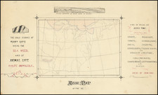
A Geological Map of the United States By The Father of American Geology
The Melish-Maclure map of the United States is one of the first geological maps of the United States published in America.
The present example, with massive margins, was found among a collection of papers of Charles Alexandre Lesueur, who was recruited by Maclure to work on the survey which created this map.
This scarce map of the United States, was issued in William Maclure's report, Observations on the Geology of the United States. Maclure, known as the "father of American geology," published the first widely available geologic map of the United States in 1809. And while this is the third issue of the map (1809 in Philadelphia and 1811 in Paris), it is "generally considered as the starting point for the geology of North America" (Marcou & Marcou).
The map is color-coded to indicate the location of Primitive Rocks, Transition Rocks, Secondary Rocks, Alluvial Rocks, and Old Red Sand Stone, based on the Wernerian classification system. Also keyed to the legend is a "line to the westward of which has been found the greatest part of the Salt & Gypsum." The map is filled with information on Indian tribes, forts, roads and early settlements. Illinois Territory is located well away from Lake Michigan and bounded on the north by the large North West Territory. Chicago is correctly located, but is on the border between Indiana and North West Territory. Of particular interest are distance notations along several major roads in miles. A legend locates canals, boundary lines and roads.
The map is one of the earliest maps to show the newly formed Alabama Territory and identifies a massive Missouri Territory, west of the Mississippi River. Indiana is directly below Lake Michigan, with Illinois Territory pushed far to the West off Lake Michigan and Chicago shown in Indiana.
Maclure (d. 1840) was a very important early American scientist and geologist. He was the founder and President of the Academy of Natural Sciences at Philadelphia, and was also the President for some years of the American Geological Society. His Observations. . . is considered the first connected account originally written in English on the geology of the U.S. Maclure became a member of Robert Owen's socialistic community in New Harmony (founded in 1826), became a large land owner in this area, and later started his own splinter group called "Macluria."
Charles Alexandre Lesueur
Charles Alexandre Lesueur (1778-1846) was a French-born artist and naturalist who is perhaps most remembered for his extensive work as artist on Nicolas Baudin's 1800-1804 expedition to Australia and the southern Pacific. In an era of generalist naturalists, Lesueur distinguished himself in a variety of fields, including paleontology, archaeology, ichthyology, and zoology.
A little-known chapter in Lesueur's varied career dates to his time in Philadelphia, where he moved in 1816, shortly after meeting noted Scottish-born American geologist William Maclure. Lesueur quickly became part of the close-knit circle of scientists and artists in Philadelphia (even influencing John James Audubon, with whom he worked teaching art in Mme. Marie Fretageot's girl's boarding).
Lesueur was elected to several American learned societies, including the Academy of Natural Sciences of Philadelphia and the American Philosophical Society. He published numerous papers on natural history, often illustrating the works himself. It is believed that Lesueur learned the lithographic technique, invented in Europe by Alois Senefelder in the 1790s, while still in Europe. He certainly imported lithographic stones from Europe into the United States at an early date. Another figure of note at this time was Marie Duclos Fretageot - also an associate of William Maclure's - a teacher at a Pestallozzian school in Paris who had studied with Senefelder. Fretageot brought one of the Senefelder's papirographic presses with her to the United States per Maclure's instructions.
John Melish (1771-1822) was the most prominent American mapmaker of his generation, even though his cartographic career lasted only a decade. Melish was born in Scotland; he moved to the West Indies in 1798 and then to the United States in 1806. By 1811, he had settled in Philadelphia and published Travels through the United States of America, in the years 1806 & 1807, and 1809, 1810, & 1811, which was richly illustrated with maps.
Melish created several regional maps of the highest quality, as well as the Military & Topographical Atlas of the United States (Philadelphia, 1813, expanded 1815). The latter work is widely considered to be the finest cartographic publication to come out of the War of 1812.
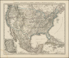
By far his best-known work is his monumental map of the United States of 1816, Map of the United States with the contiguous British and Spanish Possessions. He began working on the map in 1815 and sent it to Thomas Jefferson for comment in 1816. Jefferson enthusiastically reviewed the map and returned it with his edits. Jefferson later hung an example of the map in the Entrance Hall of Monticello and sent it to associates in Europe.
Melish’s finished product was the first map of the United States to extend to the Pacific Ocean. After its publication in 1816, Melish ensured the map was as up-to-date as possible; it was reissued in 25 known states published between 1816 and 1823. The map captured the then rapidly changing geography of the United States, as well as various boundary disputes, treaties, and expansion.
Charles Alexandre Lesueur was a French naturalist, artist, lithographer and explorer, whose productive career touched on three continents.
Lesueur was also a prolific natural history collector, who was responsible for describing numerous species, including the spiny softshell turtle (Apalone spinifera), smooth softshell turtle (A. mutica), and common map turtle (Graptemys geographica). Both Mount Lesueur and Lesueur National Park in Western Australia are named in his honor.
After a brief naval career (1797-1800), Lesueur joined Nicolas Baudin's expedition to Australia in 1801. During the course of the expedition, he took on the duties of both artist and naturalist, as a result of crew member attrition. In all, the expedition resulted in the collection of over 100,000 zoological specimens and Baudin created a vast number of highly important drawings, which later be published in the official account of Baudin's expedition.
A pioneer of lithography, Lesueur had already added lithography to his many talents before being invited to America by famed American geologist William Maclure. He made what many believe to be the first American lithograph of a natural history subject, a plate depicting two fish which accompanied some copies of the October 1821 issue of the Journal of the Academy of Natural Sciences of Philadelphia. Lesueur was so unhappy with the result that he substituted a copperplate engraving for the original lithograph; thus only a few copies of the Journal contained the now extremely rare lithograph. While residing in Philadelphia, he would go on to teach and experiment with a number of America's earliest lithographers. He become a member of the American Philosphical Society in 1817.
From 1826 to 1837, Lesuer lived in New Harmony, Indiana, while also taking trips to explore the American back country. He would encounter many important American and foreign travelers, including Karl Bodmer and Prince Maximilian.
Late in life, he returned to France to continue his career as an artist and naturalist, where he was awarded the honor of Chevalier de l’Ordre Royal de la Légion d'honneur for his long years of work in the sciences.
![[Signed Political Satire Artwork] Vietnam ... Vietnam ... Vietnam ...](https://storage.googleapis.com/raremaps/img/small/68726.jpg)
![[ English Plantations in North America ] A New Map of the most Considerable Plantations of the English In America Dedicated to His Highness William Duke of Glocester.](https://storage.googleapis.com/raremaps/img/small/98233.jpg)