|
||

|

|
|

|
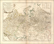
Unusual pair of maps of the Caspian Sea and Kamchatka, published by JB Homann.
The two maps surround a decorative central image withh allegorical figures and putti in a cloud background. The map of the Caspian Sea is drawn from Karl van Verden's 1722 survey of the Caspian, the first accurate map of the sea the region. The second map cover the Jedso as part of the Kamchatka Peninsula with a huge unnamed landmass (reminiscent of the Compagnies Land on earlier maps) to the east. The image is drawn from a Russian expedition in 1697 that encountered a shipwrecked Japanese in Kamchatka. The sailor told the Russians that Japan was not far from Kamchatka and that the sea between was strewn with islands.
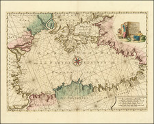
North Pacific chimeras: Yesso, De Gama, and Compagnie Land
The etymology of the idiom Yesso (Eso, Yeco, Jesso, Yedso) is most likely the Japanese Ezo-chi; a term used for the lands north of the island of Honshu. During the Edō period (1600-1886), it came to represent the ‘foreigners’ on the Kuril and Sakhalin islands. As European traders came into contact with the Japanese in the seventeenth century, the term was transferred onto European maps, where it was often associated with the island of Hokkaido. It varies on maps from a small island to a near-continent sized mass that stretches from Asia to Alaska.
The toponym held interest for Europeans because the island was supposedly tied to mythic riches. Father Francis Xavier (1506-1552), an early Jesuit missionary to Japan and China, related stories that immense silver mines were to be found on a secluded Japanese island; these stories were echoed in Spanish reports. The rumors became so tenacious and tantalizing that Abraham Ortelius included an island of silver north of Japan on his 1589 map of the Pacific.
Yesso is often tied to two other mythical North Pacific lands, Gamaland and Compagnies Land. Juan de Gama, the grandson of Vasco de Gama, was a Portuguese navigator who was accused of illegal trading with the Spanish in the East Indies. Gama fled and sailed from Macau to Japan in the later sixteenth century. He then struck out east, across the Pacific, and supposedly saw lands in the North Pacific. These lands were initially shown as small islands on Portuguese charts, but ballooned into a continent-sized landmass in later representations.
Several voyagers sought out these chimerical islands, including the Dutchmen Matthijs Hendrickszoon Quast in 1639 and Maarten Gerritszoon Vries in 1643. Compagnies Land, often shown along with Staten Land, were islands sighted by Vries on his 1643 voyage. He named the islands for the Dutch States General (Staten Land) and for the Dutch East India Company (VOC) (Compagnies, or Company’s Land). In reality, he had re-discovered two of the Kuril Islands. However, other mapmakers latched onto Compagnies Land in particular, enlarging and merging it with Yesso and/or Gamaland.
In the mid-eighteenth century, Vitus Bering, a Danish explorer in Russian employ, and later James Cook would both check the area and find nothing. La Perouse also sought the huge islands, but found only the Kurils, putting to rest the myth of the continent-sized dream lands.
Johann Baptist Homann (1663-1724) was a mapmaker who founded the famous Homann Heirs publishing company. He lived his entire life in Bavaria, particularly in Nuremberg. Initially, Johann trained to become a priest before converting to Protestantism and working as a notary.
In 1702, Johann founded a publishing house that specialized in engravings. The firm flourished, becoming the leading map publisher in Germany and an important entity in the European map market. In 1715, Johann was named Imperial Geographer to the Holy Roman Empire by Charles VI and made a member of the Prussian Academy of Sciences. Most importantly for his business, his reputation and contacts gained him imperial printing privileges which protected his publications and recommended him to customers. Johann is best known for this Grosser Atlas ueber die ganze Welt, or the Grand Atlas of the World, published in 1716.
After Johann died in 1724, the business passed to his son, Christoph (1703-1730). Upon Christoph’s early death, the company passed to subsequent heirs, with the name of the company changing to Homann Erben, or Homann Heirs. The firm continued in business until 1848.