|
||

|

|
|

|
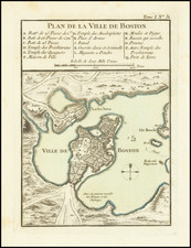
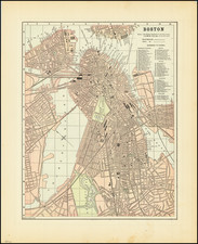
Irish Edition of the Best Chart of Boston Harbor During the First Half of the 18th Century.
Extremely rare "pirated" George Grierson edition of the 1707 Mount and Page chart of the same title, this example printed in Dublin in 1749.
The chart depicts Boston Harbor from present-day Winthrop in the north to Hull and Hingham in the south. The many islands of the harbor are depicted, with soundings covering the routes in between. A ship channel is labeled running a careful route between obstacles. In Boston proper Beacon Hill is rendered pictorially, with the shoreline of that city and nearby "Charles Town" lined with buildings, bringing to mind the "Long Wharf" View of Paul Revere.
The Leventhal Map Center at Boston Public Library notes of the map:
This chart of Boston Harbor is a rare Irish printing that was pirated from the anonymous English chart that first appeared in Mount and Page's 1707 edition of The English Pilot, The Fourth Book, as well as their 1708 edition of Atlas Maritimus Novus. However, this chart was re-engraved and printed from a separate copper plate. Although at the time, this survey was over forty years old, it continued to function as the most accurate printed chart of Boston Harbor.
Though a careful copy of the Mount & Page chart, Grierson's effort has a looser and more folky engraving style than its London-produced predecessor.
This map is very rare in commerce; OldMaps.com notes the last copy for sale was in 1986.
George Grierson (c.1678 - 1753) was one of the most important publishers, editors and mapmakers in 18th Century Ireland. Born in Dumfriesshire, Scotland, he immigrated to Ireland as a young man and in 1703 founded a printing house in Dublin at "The Sign of the Two Bibles" on Essex Street.
Dublin was then one of the most important cities in the British Empire, being a bustling port and a financial and services center. However, it had a relatively underdeveloped publishing sector. Up to this point, printing had been hampered by ongoing political instability throughout the 17th Century, with a relatively strict regime of official censorship and the overwhelming market dominance of London printers. Especially with respect to cartographic printing, Dublin's footprint was minuscule, with even most surveys of Ireland being printed in England. Grierson boldly stepped into the void and more than any other figure transformed Dublin into a major printing hub.
Much misinformation has been written about Grierson. Indeed, from reading much of the material written in catalogs and on the internet, one gains the erroneous impression that he was an intellectual property "pirate" and some sort of disreputable fly-by-night journeyman printer. In reality, he was the leading publisher in Ireland, a highly respected member of the Dublin upper sets, as well as innovative and a risk-taking entrepreneur. While he printed works originated by others, he always did this within copyright laws and always with attribution. In this sense, he was no different than any mapmaker who issued their own edition of a map previously issued (a common and well-accepted norm).
Grierson started out printing Bibles and other religious texts but eventually moved into printing classics and literature. He produced important editions of Milton's Paradise Lost and Jonathan Swift's Gulliver's Travels. His series of affordable pocket-sized books, Grierson's Classics, were bestsellers of the era.
At one point in the 1720s, he hired Constantia Crawley (1705-32), a young and exceptionally brilliant classical scholar and poet. They were married in 1727 and the charismatic Constantia did much to improve the public reception of the hardworking but comparatively taciturn Scotsman. Following Constantia's untimely death, Grierson solidified his dominance of Irish publishing upon marrying Jane Blow, the daughter of James Blow, Belfast's leading printer.
In 1729, Grierson was appointed to become the "King's Printer" for Ireland, a highly lucrative and honorific post, in which capacity he was responsible for printing all parliamentary and government papers.
His first major foray into cartography was his publication of the first Irish edition of Sir William Petty's atlas of Ireland (1732), originally issued in London in 1685.
Following the death of Herman Moll, in 1732, Grierson set about producing Irish editions of Moll's maps which were no longer under copyright.
As noted by Dennis Reinhartz in The Cartographer and the Literati - Herman Moll and his Intellectual Circle:
"…two editions of [Moll's Large Atlas] The World Described... were done by the Dublin publisher George Grierson... all of the maps in the Irish editions were completely re-engraved, even to the point of understandably having been rededicated to contemporary Irish notables. The Grierson atlas had new and/or changed cartouches, dedications, details, and comments. It also showed obvious erasers and additions, and some of the maps were updated."
Many of these maps (such as the present map) were exceedingly large and preparing the copper-plates was a major technical undertaking never before attempted in Ireland. This explains why some of Grierson's editions may appear to be somewhat crude in style compared to the London editions. Far from being due to carelessness, these imperfections are due to the growing-pains of attempting something bold and ambitious in a new setting.
While his editions of Moll's maps were likely also issued separately, Grierson issued complete editions of Moll's atlas, The World Described. Ashley Baynton-Williams, the foremost authority on maps published in the British Isles, reports that only two examples of the Grierson edition of The World Described are recorded. One example is to be found in the collections of the Royal Geographic Society (London) and the other at the Library of Trinity College (Dublin), although it is not known if these atlases are complete.
Grierson followed this up with his own edition of Mount & Page's sea atlas, The English Pilot (1749), being the first sea atlas printed in Ireland.
Grierson succeeded in greatly expanding the ambitions and technical capabilities of the printing industry in Ireland, which in turn assisted the flourishing of Irish writers and artists in the decades to come. George Grierson died in 1753 and was succeeded in the business by his son Boulter Grierson, who notably reissued his father's edition of The English Pilot in 1767. The Grierson firm continued to operate for the next three generations.
![[Boston Harbor and Environs] Coast Chart No. 9 Boston and Approaches . . . Massachusetts Bay with the Coast from Cape Ann to Cape Cod . . . 1872](https://storage.googleapis.com/raremaps/img/small/90721.jpg)