|
||

|

|
|

|
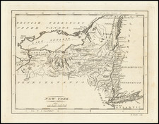
1778 edition of Esnaut & Rapilly's scarce, separately published, and attractive map of the Northeast, produced to inform the French public of the primary theatre of the early years of the American Revolution.
Of great significance at the time, the map shows and notes the location of Burgoyne's surrender to the American army at Saratoga. This victory more than any other single event induced the French to ally with the American cause in 1778 and thus is generally considered the turning point of the war. Numerous forts, minor as well as major ones, are shown and named throughout the map, including Fort Washington in northern Manhattan, those along the Delaware River, many in northern Massachusetts, and the several in the Lake Champlain/ Lake George region.
This is the second state of the map; with other states of 1777 and 1787 known.
An important French map of the northern American colonies shown at the beginning of the American Revolution. Also of interest are a number of major and minor cities including New York, Philadelphia, Albany, New Haven, Newport, and Boston, which are shown as walled cities.
![[Niagara Falls] Wasserfall von Niagra](https://storage.googleapis.com/raremaps/img/small/69038.jpg)
![[Assault on Fort Constitution, October 7, 1777]](https://storage.googleapis.com/raremaps/img/small/93152.jpg)
![[Flint River Falls / Finger Lakes] Chute de la riviere des pierres a chaux | Falls on the Flint River](https://storage.googleapis.com/raremaps/img/small/91335.jpg)