|
||

|

|
|

|
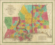
Detailed map of Mississippi, showing towns, townships, roads, railroads, train stations, rivers, lakes, etc.
Bankston, a ghost town and former manufacturing powerhouse for the Confederate Army, before its textile mills were burned down, appears in Choctaw County. Scranton, the present-day site of downtown Pascagoula, is shown along the New Orleans and Mobile Railroad. In Warren County, "Cut off 1867" denotes when the Mississippi made a shortcut, cutting the land in Davis Bend (named for its owner, Confederate President Jefferson Davis) into Davis Island.
Gray was one of the most successful atlas publishers of the 1870s and one of the last to employ hand coloring.
O. W. Gray was a publishing firm based in Philadelphia. Later, they published as O. W. Gray & Son. They published atlases in the late nineteenth century. Gray's National Atlas was one of the most successful commercial ventures of the 1870s and one of the last to employ hand coloring on maps.

![[ Map of the Mississippi River ]](https://storage.googleapis.com/raremaps/img/small/99811.jpg)
![[Supplying The Confederacy -- Letter Regarding Supplies for the Confederate Army ]](https://storage.googleapis.com/raremaps/img/small/95452.jpg)