


|
||

|

|
|

|
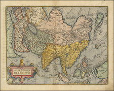
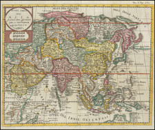
Blaeu’s Monumental Map of Asia—Rare Italian Edition
Remarkably well preserved example Blaeu’s famous, and exceedingly rare, wall map of Asia.
Published in Venice in about 1646 by Stefano Scolari, this is the earliest example of the map published outside of Amsterdam, the present example being a previously unknown early state.
As described in greater detail below the map is a tour de force in contemporary cartographic information, most notably in Southeast Asia, the Arabian Peninsula, China and Korea.
First published in about 1609, Blaeu’s original map of Asia was, at the time of publication both a monumental work of visual artistry and at the cutting edge of cartographic knowledge. Blaeu enjoyed the benefit of access to the newest information coming early Dutch explorations in the region, and would later become the official mapmaker of both the Dutch East India Company and Dutch West India Company. His first set of maps were issued in 1608 and 1609, a wall map of the World, the four continents and the Holy Roman Empire. With no recorded examples of the complete 1609 Asia map surviving to this date and only a few examples of the later printings. Beginning with the present map of 1646, several Italian and French publishers made close copies of the original Blaeu wall map of Asia, with the present example being the earliest known example.
The present map is a spectacular example of the grand genre of wall, or parlor, maps that enjoyed an iconic place in 17th and early 18th-century Europe. At the pinnacle of this genre were the maps of the Blaeu family, generally regarded as the finest wall map makers of the Golden Age. Large, highly decorative and expensive productions, they were considered to be the ultimate signs of wealth and intellectual sophistication. In this vein, Blaeu wall maps appeared prominently in works of fine art, most notably the paintings of Johannes Vermeer. Displayed in the salons of leading merchants and noblemen, the maps were especially prone to damage and their survival rate is extremely low, especially in this condition.
Contents and sources
The map shows Asia in great detail, utilizing Portuguese charts and sources from early Dutch expeditions to the East Indies. It stretches from Egypt to the Marianas (Ladrones), and from the Arctic to Java.
The major cartographic change by Scolari is the re-engraving of New Guinea. Blaeu’s original shows the island of Ceiram. However, the 1615-1617 circumnavigation of Le Maire and Schouten added new information about the coast of New Guinea (and Tierra del Fuego), which is shown on this map. The western end of the previous island is still visible.
Beyond this change, the map offers a well-researched overview of Asia as understood in Amsterdam at the start of the seventeenth century. The Great Wall of China is included, as are many narrative notes borrowed from voyage and travel accounts as old as Marco Polo and as recent as the first Dutch voyages to the East Indies and Japan at the turn of the seventeenth century. The Dutch were expanding their trading empire at this time, as well as starting to dominate the map trade. When this map was originally compiled in the first decade of the seventeenth century, the Dutch were making inroads in the East Indies spice trade and the China trade in places like Macao. The map does not include Australia, but the Dutch would also encounter that landmass in the first decades of the century.
Inland areas are thickly blanketed with towns, mountains ranges, deserts, and other features. For example, the Arabian Peninsula shows many settlements ringing the coasts before giving way to a desert interior. It also has sites that are still familiar today. These include Bahrem (Bahrain), Mt. Sinai, Mecca, and Medina.
The map shares many details with Blaeu’s 1605 world map. Both show the Strait of Anian (see below). Southeast and East Asia are drawn from Portuguese maps and charts. The Ganges is shown on a mistaken course and there are no Himalayas, underlining that there was much still to be learned. Indeed, the Malaccan Peninsula and the Gulf of Siam are more precise and detailed here than on the 1605 world map, showing how Blaeu was improving his geography in a few short years. Similarly, Korea is still shown as an island here, but it is elongated rather than circular (see below).
On the Malaccan Peninsula is Sincapura, or Singapore. At this time, the name referred to a trading settlement, although the town had earlier ties to both the Kingdom of Siam and the Majapahit Empire. Soon after this map was made, in 1613, the Portuguese burned the settlement, making this a fleeting glimpse of the place in a time of transition.
Much here has been taken from the voyage accounts of Jan Huyghen van Linschoten. As a young man, Linschoten traveled the world as part of the Portuguese East Indies trade. In 1583, his brother secured him a position as the Secretary to the Archbishop of Goa, a Portuguese colony. While abroad, he kept a diary, and began collecting other travelers’ diaries and accounts upon his return.
In 1594, Linschoten set out with Willem Barentsz on an exploratory expedition to find the Northeast Passage. The crew had many adventures, including an encounter with a polar bear, which they killed while attempting to capture it. Eventually, the crews had to turn back because of ice, a situation that also happened with a similar expedition the following year. Upon his return, Linschoten published his journal from the Barenstz voyages. In 1595, he also published Reysgheschrift vande navigation der Portugaloysers in Orienten (Travel Accounts of Portuguese Navigation in the Orient) based on his research. The work includes sailing directions in addition to descriptions of lands still new to Europeans, like Japan.
The Arctic here is based on Linschoten and other recent exploration. Novaya Zemla and Spitsbergen were both drawn from the first two voyages of Henry Hudson in 1607 and 1608. The image of the reindeer and the sleigh, and of the “Samoiedae” are based on Linschoten’s account of his time with Barentsz. The inset is meant to show off these recent expeditions. The text translates as:
Four different times, viz. in 1594, ’95, ’96 and 1609, the Dutch bravely tried to locate a passage through the northernmost regions of Europe and Asia close to the North Pole in order to find an easier navigational route to Cathay and China. As the situation of these regions cannot be seen accurately enough, because they are not depicted in an overlapping way, we have decided to present them to the conscientious observer on a separate map (Schilder, MCN, vol. V, p. 138).
In 1597, Linschoten published again, this time a description of the African coast. His most famous work, however, is Itinerario: Voyage ofte schipvaert van Jan Huyghen van Linschoten naer Oost ofte Portugaels Indien, 1579-1592 (Travel account of the voyage of the sailor Jan Huyghen van Linschoten to Portuguese East India). It was published in 1596 by Cornelis Claesz, an associate of Blaeu’s in Amsterdam. It was quickly translated into English (1598), German (1598), and French (1610). Latin editions appeared in Frankfurt and Amsterdam in 1599. It also contained important, detailed maps by the van Langrens which formed the foundation for this map's depiction of the East Indies and for the information about spices and local animals.
Another text cartouche, this one in the interior of Africa, explains how to calculate distance with a pair of compasses. This indicates that, however ornate the maps were, they were intended for at least some practical use as well. The translation is:
The distances of places to be calculated with the pair of compasses. On a drawn circle AENMBSD, divided into 360 parts, and with a diameter ACB, the difference in longitude of two places must be subtracted, from A down; a radius should be drawn to the end of the count, here for instance D. Then the largest latitude must be drawn, from A upwards, where one ends in E. A perpendicular EF must be dropped on the underlying diameter AB. However, the smallest latitude must be subtracted from D in the direction of B. From that point, here G, a perpendicular GH is dropped on the radius DC. The distance of the points FH is cut off (from the diameter) from F in the direction of B, and this equals FK. Then, provided the latitudes are homogenous, (that is; both belonging to either the northern or the southern hemisphere), one cuts off EI, which equals the perpendicular HG, from the long perpendicular EF from E in the direction of F. Then the straight line IK (the connection between the points I and K) is the chord of the required distance of the places. If one draws this upwards from B to the circumference of the circle, the arc BM indicates how many degrees and consequently how many miles the places you postulated are apart from each other. If the latitudes are heterogenous, the straight line FE must be drawn as far as L, so that EL equals the perpendicular GH. Then KL is the chord of the distance you asked. You draw it upwards to the circumference of the circle and BN provides the distance of your places in degrees (Schilder, MCN, vol. V, pgs. 137-8).
Decorative elements
Blaeu’s continental maps also well known for the decorative borders. The decorative elements were originally etched by Hessel Gerritsz and have been skillfully rendered here on this Italian edition.
Blaeu's use of these decorative elements would make these paneled maps with costumes and cities framing the cartography the highest form of decorative artwork on maps. While Abraham Ortelius, Jodocus Hondius and Claes Jansz Visscher had issued similar maps in the prior decades, it was Blaeu's work that most widely disseminated the genre. . They were first seen in Amsterdam thanks to the work of Van der Keere in 1596, but they were most successfully utilized by Hondius, back in Holland, and Blaeu. For example, there are superb borders on Jodocus Hondius' fifteen-sheet map of Europe (1595), the first to introduce costumed figures on the sides. They are also present on Jodocus Hondius's twenty-sheet map of the world (1605), which adopted round and oval town views for the first time. The trend of decorative borders spread across Europe and lasted in the Netherlands until the that later part of the 17th Century.
The costumed figures shown here are drawn from a variety of sources including costume books, popular prints, and travel literature. The Chinese come from De Bry images, while the Japanese and the Marianas islanders are taken from De Noort’s voyage account. The Tartars are inspired by the prints of Eneo Vito, while the Muscovites are based on the work of Joost Amman. The Syrians are from Nicolas de Nicoloay and the Gujaratis from Linschoten.
The twelve town and city views also originate from travel writing and city books, especially Braun and Hogenberg’s Civitates Orbis Terrarum. Goa is from the evergreen Linschoten, Bantam from the work of De Houtman, and Gammalamme from Van Neck.
Rarity and states
All states and editions of Blaeu’s map of Asia are rare.
The 1609 first state is known in three states:
- State 1: circa 1609. Schilder notes incomplete examples of this state appear in the collections of the BnF and the Rittersaalverein, Burgdorf. Both of these are without the decorative borders and text and may in fact be later states. An earlier example with the borders and text is here.
- State 2: 1612. One known example, Sächsisches Hauptstaatsarchiv, Dresden (Schr. II, Mappe 32 b, Nr. 3).
- State 3. 1624, Henricus Hondius imprint. Here, the text has been reset and the imprint line changed, but the geographical plates appear to have been untouched. Known in one surviving example, Herzogin Anna-Amalia Bibliothek, Weimar.
A later state by Claus Jansz Visscher is known only from external evidence with no surviving examples (fourth state, pre-1632). Nicolaas Visscher produced two states; a fifth state (dated 1657) survives in one state, and a sixth (n.d.) is known in two institutional examples and one Sotheby's sales catalog from 1980.
The map proved popular in Italy, resulting in several re-engraved editions. The present example is the 1646 edition printed in Venice by Stefano Scolari, the earliest of the Italian editions. It is apparently a unique survival, similar to the example held at the Perugia University, which has a Latin text added with the date 1646. Similar maps with slightly different titles than the present map and the Perugia example are held at the Library of Congress and the National Maritime Museum.
There were also sets of the continental maps printed in Paris in 1699 by Hubert Jaillot, Bologna by Pietro Todeschi (1673) and in Rome by R. B. de Rossi (1666 and 1686).
This strait, believed to separate northwestern America from northeastern Asia, was related to the centuries-long quest to find a Northwest Passage connecting the Atlantic Ocean to the Pacific. The rumor of this strait and a Northwest Passage in general inspired many voyages of discovery, including those of John Cabot, Sir Francis Drake, Gaspar Corte-Real, Jacques Cartier, and Sir Humphrey Gilbert.
The term Anian itself comes from Marco Polo’s thirteenth-century accounts of his travels. Polo used the term to refer to the Gulf of Tonkin, but cartographers thought it could refer to this supposed strait between Asia and North America. The Strait of Anian, so named, first appeared in a 1562 map by Giacomo Gastaldi, and was later adopted by Bolognini Zaltieri and Gerard Mercator.
The sequence of events and maps that led California to be portrayed as an island are much clearer than another famous peninsula-turned-island, Korea. Korea is briefly mentioned in the thirteenth century by Marco Polo as Cauli (Kauli), but otherwise Korea was not described again for European audiences until the late-sixteenth century.
As with Japan and China, most of the earliest bits of information about Korea came from the Jesuits sending letters sent back from East Asia. However, the Jesuits were not actually stationed in Korea; they could only glean impressions from Chinese and Japanese sources. For example, Father Luis Frois wrote of Korea in the context of a war with Japan in 1578. Frois explained that Korea was separated from Japan by a sliver of sea. It had previously been understood to be an island, he explained, but was now known to be a peninsula. However, why Korea was thought to be an island, by who, and how it was found to be a peninsula was not shared with Frois’ curious readers back in Europe.
The first known European to visit Korea was also a Jesuit, Father Gregorio des Cespedes. He accompanied Japanese troops during another war with Korea in 1592. The territory did not agree with Cespedes, who found it bitingly cold. He did not mention anything about the Korean peoples or their geography.
Travel writers, those who actually traveled and those who were more drawn to the armchair voyage, also wrote about Korea. Jan Huygen van Linschoten spent several years in Goa, India, where he had access to Spanish and Portuguese sources. In his Itinerario, first published in German and English in 1598, he suggests Korea is a large island called Core. Richard Hakluyt read the Jesuit letters, which were republished in sets of annual letters. In the second edition of his Principal Navigations (1599), Hakluyt included the information from Frois and Cespedes, scant as it was.
Given the relative dearth of source material, it is not surprising that early maps by Münster, Mercator and Ortelius omitted Korea entirely. The first map to show Korea was Orbis Terrarum Typus de Integro Multis in Locis Emendatus by Petrus Plancius (1594). It included “Corea” as a long, skinny peninsula barely attached to the northeast corner of China. Edward Wright, in the map accompanying Hakluyt’s Principal Navigations, adopted a similar depiction of Korea, as did other mapmakers from the 1590s onward.
Interestingly, the map that accompanied Linschoten’s Itinerario, by Arnold Floris van Langren, shows Korea as a large, round island. However, no other mapmaker is known to have followed this example. Another early island depiction that was widely adopted was that of Luis Teixeira in the 1595 edition of Ortelius’ Theatrum Orbis Terrarum. The long, thin island was used by several cartographers, including Jodocus Hondius, in the seventeenth century. Blaeu also used the Teixeira model before creating a new Korea in later maps that looked like a bat hanging from China, separated from the mainland by the thinnest of waterways.
Confusion over island vs. peninsula continued across seventeenth-century maps. For example, John Speed includes three separate versions of Korea across four maps in his A Prospect of the Most Famous Parts of the World (1626). It is shown on the Teixeira island model, as a thin peninsula, and as a blunt island. These various hypotheses as to the shape of Korea continued to coexist for decades.
Finally, in the 1650s, Father Martino Martini gathered more information and created a new map of Korea. In China from 1642 to 1651, Martini spent a good deal of time with Chinese maps and their makers. Thus, he created new maps showing Korea as a thicker, nearly rectangular peninsula in Bellum Tartaricum (1654) and the Atlas Sinensis (1655).
Also in the 1650s, a Dutch sailor named Hendrick Hamel was shipwrecked on Jeju, an island near southern Korea. Hamel and his fellow survivors would spend thirteen years in Korea, escaping to Nagasaki in 1666. He wrote about the ordeal in a journal that was published in 1668. Although it lacked maps, the ample descriptions confirmed that Korea gave a detailed, first-hand view of Korean geography and culture.
Nevertheless, several maps were published in the early eighteenth-century showing Korea as an island. The island myth, which most likely stemmed from a misreading of Japanese and Chinese maps by early Jesuits, proved to be quite entrenched. Only in 1735 did Jean Baptiste Bourguignon d’Anville produce a map with a roughly accurate outline of the peninsula and a relatively detailed interior.
Willem Janszoon Blaeu (1571-1638) was a prominent Dutch geographer and publisher. Born the son of a herring merchant, Blaeu chose not fish but mathematics and astronomy for his focus. He studied with the famous Danish astronomer Tycho Brahe, with whom he honed his instrument and globe making skills. Blaeu set up shop in Amsterdam, where he sold instruments and globes, published maps, and edited the works of intellectuals like Descartes and Hugo Grotius. In 1635, he released his atlas, Theatrum Orbis Terrarum, sive, Atlas novus.
Willem died in 1638. He had two sons, Cornelis (1610-1648) and Joan (1596-1673). Joan trained as a lawyer, but joined his father’s business rather than practice. After his father’s death, the brothers took over their father’s shop and Joan took on his work as hydrographer to the Dutch East India Company. Later in life, Joan would modify and greatly expand his father’s Atlas novus, eventually releasing his masterpiece, the Atlas maior, between 1662 and 1672.
Stefano Scolari was active between 1644 and 1687. He was a designer, engraver and editor from Brescia, although he practiced his trade in Venice. His shop, in S. Zulian under the sign of the Three Virtues, was one of the best known in seventeenth-century Venice. He engraved, printed, and traded in prints, particularly, maps. He specialized in the re-issue of important maps including Gastaldi's map of Lombardy and the 12-sheet map of Italy by Greuter.
![Asia Secunda Pars Terrae in Forma Pegasi [Asia in the Form of Pegasus]](https://storage.googleapis.com/raremaps/img/small/94173.jpg)