|
||

|

|
|

|
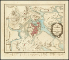
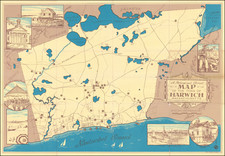
This town plan of Boston, produced by John Tallis in London in 1851, offers a fascinating glimpse into the city as it was in the mid-19th century. Notably, it includes a prominent view of Bunker Hill Monument and the State House, offering a rich visual representation of the city's notable landmarks.
This map stands out due to Tallis's distinct style of incorporating charming vignettes of local scenes and people into his designs. This feature makes his works particularly sought-after among collectors and enthusiasts. In this respect, Tallis can be considered one of the last great decorative map makers.
Furthermore, it's worth noting that the town plans produced by Tallis are relatively rare, appearing in only a small fraction of his collections. As such, this makes them more infrequent compared to his regional maps. This particular map was engraved for R. Montgomery Martin's Illustrated Atlas, underscoring its historical and artistic value.
John Tallis (1817-1876) was a British map publisher. Born in the Midlands, Tallis came to London in the 1840s. Tallis began his London career with a series of remarkable London street views. He began a partnership with a Frederick Tallis, possibly his brother, but their collaboration ended in 1849. For the Great Exhibition of 1851, Tallis published the Illustrated World Atlas, one of the last series of decorative world maps ever produced. The maps were engraved by John Rapkin, a skilled artisan. The maps were later reissued by the London Printing & Publishing Company, who left the Tallis imprint intact, thus ensuring his enduring fame. In 1858, he began publication of the popular Illustrated News of the World and National Portrait Gallery of Eminent Personages, selling it in 1861 (it ceased publication in 1863).