


|
||

|

|
|

|
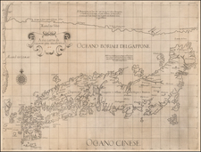
"SECRET" Beach Diagram used for Planning and Executing the American Landings on Iwo Jima.
The Intelligence that Left Marines Stranded.
Very rare color-printed view of the southeastern beaches of Iwo Jima, showing the beaches on which American marines landed on the 19th of February, 1945. This diagram would have been used by the pilots conducting strikes and the captains of LST and personnel carriers as they approached the fateful beaches.
The diagram shows the intelligence gathered by American sources from aerial photographs made more than seven months before the start of the mission. Despite the often reliable nature of these beach diagrams, particularly when involving major amphibious operations such as the Normandy Landings, this diagram fails to note the extent to which the unfavorable conditions would adversely affect the landing Americans. This would be made clear to the Americans upon landing when they discovered the steeply sloping, and very soft, volcanic sand and effective enemy defenses that plagued the beaches.
The diagram subdivides the critical southern isthmus of the island, which the marines had planned to cross on the first day. To the south of the lowlands is "Hot Rocks," the codename for Mount Suribachi, the site of the memorialized raising of the American flag. To the north are the wild reaches of the island that it would take the marines over a month to clear.
The Diagram
This diagram presents a general view of the southeastern landing beach, along with notes about the conditions in each of the roughly 500-yard-wide landing zones. The notes cover "Beach Extent", "Beach Approaches", "Nature of Beach", "Terrain Inland", "Exits", and "Obstacles". There is also a set of notes for the general conditions affecting all beaches.
These beaches, where Marines landed on February 19th, 1945, are divided into zones "Green 1", "Red 1", "Red 2", "Yellow 1", "Yellow 2", "Blue 1", and "Blue 2". On the first day of the invasion, the 4th Marine Division landed at the Blue and Yellow beaches, while the 5th Marines landed at the Green and Red. The 3rd Marine Division was held in reserve and committed to the central sector on the 22nd of February.
Mount Suribachi, or "Hot Rocks" as it was codenamed, appears at the far left or right of the diagrams. A sister diagram was produced for this map, which showed the southwestern beaches, another proposed landing area.
Accuracy of the Diagram
The diagram relied on aerial photographs made on July 4, 1944, more than seven months before the invasion. It shows little in the way of manmade impediments to amphibious invasion, belying the extensive Japanese fortifications and the dogged resistance that the Marines would face from the roughly 20,000 defenders. Eschewing Japanese doctrine, which called for him to contest every inch of the landing beaches, the commanding Lieutenant General Tadamichi Kuribayashi instead instructed his soldiers to allow the American forces to land en masse, before springing traps to kill as many newly-landed troops as possible.
American planners also misunderstood the nature of the volcanic sand and terrain of the beaches, most of which was thought to be perfectly suitable for disembarking and traversing. In these diagrams, little mention is made of the softness of this sand, and few obstacles are listed. In reality, the ash was very difficult to traverse, and equally difficult to dig into, greatly complicating the unloading of equipment and vehicles and the excavation of foxholes and trenches.
These errors were symptomatic of a general lack of accurate pre-invasion intelligence, which ultimately cost hundreds, even thousands of American lives.
Rarity
OCLC records two copies (one at Harvard and the other at East Carolina). We have previously handled a separate example of this view which was sold alongside a map of the proposed (but not used) southwestern landing beaches.
Another set of these diagrams was featured in an episode of the TV show Pawn Stars. Rick Harrison, the host of the show, wrote that he had sold one of the two views for $10,000.
Iwo Jima, whose name translates as "Sulfur Island", was an important midway point between South Pacific bomber bases that were already in the hands of the Allies and the Japanese home islands. 700 miles from Tokyo and 350 from the nearest U.S. airbase, with a central plain suitable for building large runways, American planners viewed it as a valuable target. The battle for the island was among the bloodiest of the Pacific Theater of the Second World War. In total, 6,800 U.S. Marines lost their lives and 26,000 were wounded, while a staggering 18,000 Japanese defenders died.
![[Kyoto, Japan] Plan de la Ville de Meaco](https://storage.googleapis.com/raremaps/img/small/61134.jpg)
![(Second World War - Postwar Reconstruction) [Archive of Materials Related to American Reconstruction Efforts in Bavaria]](https://storage.googleapis.com/raremaps/img/small/88055.jpg)