|
||

|

|
|

|
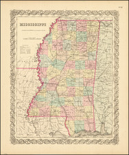
Stock# 89782
Description
Attractive map of Mississippi, hand colored by counties and showing towns, roads, railroads, steamship lines, etc.
From an early edition of Mitchell's Universal Atlas following the sale of the business to Thomas Cowperthwait.
The maps from the Universal Atlas have their beginnings with Tanner in the 1830s. Tanner sold the business to SA Mitchell in 1846. Thomas Cowperthwait & Co. published from 1850 to 1854. Following a brief period where the publisher was Cowperthwait Desilver & Butler, the maps were published by Desilver with new borders from 1855 to 1860.
![[ Map of the Mississippi River ]](https://storage.googleapis.com/raremaps/img/small/99811.jpg)