|
||

|

|
|

|
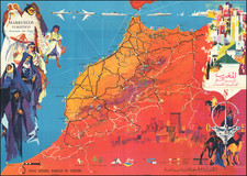
Excellent French-language map of northwestern Africa published in 1924 as the second edition. The map was drawn by A. Meunier, a geographer at the Ministry of Colonies. It is at a scale of 4,000,000 and includes text and markings in both French and transliterated Arabic. The map shows the regions of Western and Central Sahara and includes various details such as permanent and non-permanent water sources, roads, railroads, and telegraph lines. It also includes information on the various administrative divisions and military territories within the region.
In 1924, the French had a strong presence in the Western and Central Sahara regions. This map, published by the Ministry of Colonies and drawn by a geographer at the ministry, provides detailed information on the geography of the region and the various infrastructure projects undertaken by the French to facilitate their colonial endeavors. At the time of its publication, the French were actively engaged in efforts to extract natural resources from the Sahara and establish trading routes, making this map a valuable tool for colonial officials and others involved in these endeavors.
The map includes the imprint line: "Imp. Photo Metallo Millet Asnieres"
Rarity
OCLC lists five copies in institutions, however, we cannot trace any other examples having been offered on the open market.
![[Northwest Africa / Morocco] [Tabu. I. Aphricae] (title on verso)](https://storage.googleapis.com/raremaps/img/small/64911.jpg)
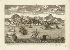
![(Early French Colonization of North Africa--Barbary Pirates) Gigeri en Afrique, Sur la Coste de Barbarie; et la Prise par les Armees du Roy, Commandes par Mr. le Duc de Beaufort [Gigeri in Africa, On the Coast of Barbary; and its Capture by the Armies of the King, Commanded by Mr. the Duke of Beaufort]](https://storage.googleapis.com/raremaps/img/small/93494.jpg)