|
||

|

|
|

|
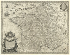
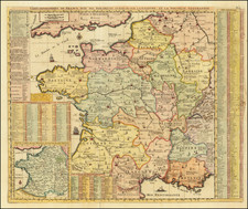
Very rare map of ancient France, published in the middle of the 18th century but showing the kingdom as it stood during the reign of Clovis and the first kings of France.
The map uses Latin names for the various regions of France; for example, the Ile-de-France region is named "Lugdunensis." The map extends eastwards further than the present-day extent of France, including parts of the Low Countries, Germany, and Switzerland, which were ruled by the same early kings of France. In the upper right is a brief history of these kings and the history of French territorial acquisitions.
This map was published by Gilles Robert de Vaugondy in Paris, whose imprint reads Sr. G. Robert and notes that he is in the employ of the king.
Gilles Robert de Vaugondy (1688-1766) and Didier Robert de Vaugondy (1723-1786) were influential figures in the realm of 18th-century French cartography. Originating from Paris, their contributions to mapmaking were significant during an era of expansive geographical exploration.
Gilles Robert de Vaugondy entered the world of cartography not through family tradition but through personal interest and the budding opportunities of his time. Born in 1688, he worked during a time when Paris was becoming a central hub for cartographic activities. Gilles often incorporated the latest findings from explorers into his maps, making them sought-after for their contemporary relevance. His connections weren't limited to his immediate circle; he frequently interacted with other key mapmakers, staying updated on the latest techniques and findings.
His son, Didier, was born in 1723 and had the advantage of growing up surrounded by maps and globes. While his father was renowned for maps, Didier made a name for himself in the field of globemaking. His globes were some of the most precise and detailed in France, gaining recognition even among the royalty. In addition to his work in cartography and globemaking, Didier had a keen interest in education, especially after the expulsion of the Jesuits from France. He stepped in to produce geographical educational materials, fulfilling a newfound need.
The maps and globes produced by the Vaugondys remain an enduring testament to the peak of French cartography during the Enlightenment. Their works, characterized by precision and the inclusion of contemporary findings, helped to shape our understanding of the world during a transformative period in European history.
![[ France / Roman Gaul ] Galliae Veteris Typus](https://storage.googleapis.com/raremaps/img/small/98777.jpg)