


|
||

|

|
|

|
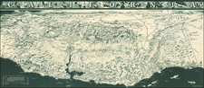
The First Mexican Sea Chart of the Pacific Coast
Extremely rare section of a multi-sheet map of the Pacific Ocean, issued by order of the first President of Mexico, Don Guadalupe Victoria.
Originally intended as a 6 sheet chart of the Pacific, this is one of the earliest maps printed by the Mexican Government and bears the insignia of the nascent Mexican Hydrographical Department. There is some lore of the map that suggests it was intended as a gift from the King of Spain for Mexico's independence or that it was published in London, but what is certain is that it was never finished and that it commemorates Mexico's Independence from Spain, having been published in the year the Mexico finally pushed Spain out of Veracruz and completed is quest for independence.
Fine sea chart of the Pacific coast from Alaska to Panama, including the Hawaiian Islands, and designates coastal cities and other points of interest along the Gulf of Mexico.
As noted by Rumsey, it is likely that only the top two sheets were ever printed, and the western of the two sheets is virtually unobtainable:
First Mexican edition of Espinosa y Tello's chart of 1814. . . . Mexican edition [has] borders that suggest [printing of other] sheets, although it is not known if they were printed. . . . "Longitude oeste de Cadiz". Emblem with eagle perched on boat surrounded by 2 sails and 2 anchors in lower left corner of the east sheet. Relief shown by hachures. Depth by soundings. Shows routes of Spanish voyages and date of exploration in the Pacific, including the Northwest Coast of North America. Covers northwest coast of America, Kamchatka, Japan, the Philippines, Hawaii & most of Micronesia.
Rarity
The sheet is very rare. Streeter had only this sheet.
The complete set does not seem to exist and it is unlikely that the lower 4 sheets were completed.
![Tabula Terre Nove [The Admiral's Map]](https://storage.googleapis.com/raremaps/img/small/81714.jpg)
![Wailuku [Maui]](https://storage.googleapis.com/raremaps/img/small/61147.jpg)
![Naufrage De M.M. De Laborde Sur Les Canots De La Peyrouse Au Port Des Francois Dans La Californie . . . [Shipwreck of the Astrolabe's yawl at Port des Francais, Lituya Bay, Alaska]](https://storage.googleapis.com/raremaps/img/small/52480.jpg)