|
||

|

|
|

|
Stock# 89605
Description
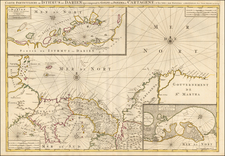
Rare antique map of the Americas, first published three years after the Louisana Purchase, with an inset map of the polar regions of North America.
Colonial possesions are indicated with specific hand-coloring by the colonial power. East and West Florida are shown as Spanish possessions. Dutch Guyana, to the west of French Guyana, was officially ceded to the British under the Anglo-Dutch Treaty of 1814.
The inset map of the Canadian Arctic is titled "Die nordlichen Lander von America."
The cartographer mapped a few phantom islands, including Jacquet and Mayda islands, with a warning he is skeptical of their location or existence.
Condition Description
Original hand-color in outline. Minor foxing. Minor centerfold mend at the bottom edge, most likely accomplished at an early date with early paper.