This item has been sold, but you can enter your email address to be notified if another example becomes available.


|
||

|

|
|

|
Stock# 89561
Description
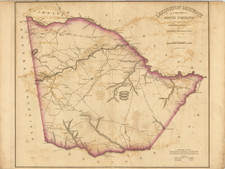
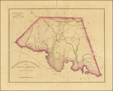
Detailed U.S. C. & G.S. map of the entrance to the North Edisto River, just south of Chalreston, South Carolina.
The map covers parts of Seabrook Island, north Edisto Island, and somewhat more inland farms and wetlands. The hamlet of Rockville is depicted, with each building rendered. Point of Pines House is shown. Ground cover and bathymetric data is depicted in great detail.
Condition Description
Thick paper edition, printed in 1892. Purple ink stamp indicating printing date.