|
||

|

|
|

|
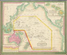
The Vast South Seas, with Mythical Lands and California as an Island
Geraard Van Keulen’s striking chart of the Pacific Ocean, including California as an island.
The chart stretches from New Guinea to western Brazil, and from Japan and the far North Pacific—which is filled with hypotheses and chimeras—to Aotearoa/New Zealand. The east coast of North America and the Caribbean are also included, a reference to the connection of trade in the two oceans via New Spain and the Isthmus of Panama, as well as around the south of South America.
The world’s largest ocean is peppered with islands, some confirmed and some conjectural. New Zealand is shown only as a stretch of coastline, that seen by Abel Tasman during his voyage of 1642 to 1644. He also charted southern Van Diemen’s Land on that voyage; the landmass is now known to be the island of Tasmania.
The coast of New Guinea is labeled with toponyms from the circumnavigation of Le Maire and Schouten from 1615 to 1617. That same voyage was the first to round Cape Horn, proving that Tierra del Fuego is an island and providing an alternate route into the Pacific other than the Strait of Magellan.
The North Pacific has ghostly coastlines that are unfamiliar to the modern eye. These are based on voyages in search a land supposedly seen by Juan de Gama (see below). The other strange island is a very familiar one, California, which was briefly a feature on maps in the seventeenth and eighteenth centuries (see below).
Another strange landmass looms near New Zealand. It is labeled as, “Het Onbekende Zuyd Land,” or the unknown south land. Early modern European geographers subscribed to the idea that there had to be a southern continent that balanced out their northern counterparts. The search for such a continent fueled many voyages over the centuries. The coastline shown here was supposedly seen by Hernando Gallego, the pilot on the first voyage of Alvaro de Mendaña (1565-7), which visited the Solomon Islands.
A tiny island near what is today Argentina is labeled as Pepys Island. Samuel Pepys was a British naval administrator and served as President of the Royal Society. This island was named for him in the 1680s by a buccaneer and lingered on maps for a century before naval explorers like John Byron and James Cook confirmed that it did not exist.
Quiri Regio
Near to New Guinea is Quiri Regio. This toponym refers to the speculative coastline of the voyages of Pedro Ferdinand de Quiros at the turn of the seventeenth century. Quiros was a skilled pilot who accompanied Alvaro de Mendaña on his second voyage to the Solomons in 1595-6 (the first voyage took place in 1567-9).
After returning to Spain, Quiros convinced authorities that he could find Terra Australis, the southern continent, if they gave him ships and supplies. He set out in 1605 and eventually landed in Vanuatu. He mistook one of the islands for the fabled continent and called it Austrialia de Espiritu Santo. The largest island in the chain is still called Espiritu Santo today. This is the island of Quiri Regio shown here.
Quiros intended to set up a colony on the supposed continent. He performed a series of elaborate possession rituals and founded a city he called Nueba Hierusalem. The “city” was nestled between two rivers which Quiros called the Jordan and the San Salvador (likely today’s Jordan and Vitthié Rivers). However, his crew forced him to leave. Quiros returned to Mexico, but his second-in-command sailed west, through the strait now bearing his name. Due to state secrecy, however, the strait remained largely unknown until the 1760s.
Upon his return, Quiros revved up his campaign, lobbying once again for a voyage to return to his supposed southern continent. To gain support, Quiros wrote at least fifty memorials to advertise his successes and lay out his plans. Fourteen of these were printed between 1607 and 1614.
The most widely circulated was the Eighth Memorial. In it, he describes Austrialia de Espiritu Santo to be as wide as Europe, Asia Minor, the Caspian Sea, and Persia combined, “in its outline it quarters the entire Globe.” Printed in Madrid in 1608 and Seville in 1609, the Eighth Memorial was reprinted in 1612 by Dutch cartographer Hessel Gerritsz in his Detectio Freti Hudson. It continued to be use as a source for mapmakers well into the eighteenth century.
States of the chart
The chart includes the name of Gerard van Keulen, who took over the van Keulen firm in 1704. It was included in editions of volume V of the popular De nieuwe Groote ligtende zee-fakkel.
According to McLaughlin, this is a second state of the chart, as it includes New Guinea and Quiri Regio.
This strait, believed to separate northwestern America from northeastern Asia, was related to the centuries-long quest to find a Northwest Passage connecting the Atlantic Ocean to the Pacific. The rumor of this strait and a Northwest Passage in general inspired many voyages of discovery, including those of John Cabot, Sir Francis Drake, Gaspar Corte-Real, Jacques Cartier, and Sir Humphrey Gilbert.
The term Anian itself comes from Marco Polo’s thirteenth-century accounts of his travels. Polo used the term to refer to the Gulf of Tonkin, but cartographers thought it could refer to this supposed strait between Asia and North America. The Strait of Anian, so named, first appeared in a 1562 map by Giacomo Gastaldi, and was later adopted by Bolognini Zaltieri and Gerard Mercator.
North Pacific chimeras: Yesso, De Gama, and Compagnie Land
The etymology of the idiom Yesso (Eso, Yeco, Jesso, Yedso) is most likely the Japanese Ezo-chi; a term used for the lands north of the island of Honshu. During the Edō period (1600-1886), it came to represent the ‘foreigners’ on the Kuril and Sakhalin islands. As European traders came into contact with the Japanese in the seventeenth century, the term was transferred onto European maps, where it was often associated with the island of Hokkaido. It varies on maps from a small island to a near-continent sized mass that stretches from Asia to Alaska.
The toponym held interest for Europeans because the island was supposedly tied to mythic riches. Father Francis Xavier (1506-1552), an early Jesuit missionary to Japan and China, related stories that immense silver mines were to be found on a secluded Japanese island; these stories were echoed in Spanish reports. The rumors became so tenacious and tantalizing that Abraham Ortelius included an island of silver north of Japan on his 1589 map of the Pacific.
Yesso is often tied to two other mythical North Pacific lands, Gamaland and Compagnies Land. Juan de Gama, the grandson of Vasco de Gama, was a Portuguese navigator who was accused of illegal trading with the Spanish in the East Indies. Gama fled and sailed from Macau to Japan in the later sixteenth century. He then struck out east, across the Pacific, and supposedly saw lands in the North Pacific. These lands were initially shown as small islands on Portuguese charts, but ballooned into a continent-sized landmass in later representations.
Several voyagers sought out these chimerical islands, including the Dutchmen Matthijs Hendrickszoon Quast in 1639 and Maarten Gerritszoon Vries in 1643. Compagnies Land, often shown along with Staten Land, were islands sighted by Vries on his 1643 voyage. He named the islands for the Dutch States General (Staten Land) and for the Dutch East India Company (VOC) (Compagnies, or Company’s Land). In reality, he had re-discovered two of the Kuril Islands. However, other mapmakers latched onto Compagnies Land in particular, enlarging and merging it with Yesso and/or Gamaland.
In the mid-eighteenth century, Vitus Bering, a Danish explorer in Russian employ, and later James Cook would both check the area and find nothing. La Perouse also sought the huge islands, but found only the Kurils, putting to rest the myth of the continent-sized dream lands.
The popular misconception of California as an island can be found on European maps from the sixteenth through the eighteenth centuries. From its first portrayal on a printed map by Diego Gutiérrez, in 1562, California was shown as part of North America by mapmakers, including Gerardus Mercator and Abraham Ortelius. In the 1620s, however, it began to appear as an island in several sources. While most of these show the equivalent of the modern state of California separated from the continent, others, like a manuscript chart by Joao Teixeira Albernaz I (ca. 1632) now in the collection of the National Library of Brasil shows the entire western half of North Americas as an island.
The myth of California as an island was most likely the result of the travel account of Sebastian Vizcaino, who had been sent north up the shore of California in 1602. A Carmelite friar, Fray Antonio de la Ascensión, accompanied him. Ascension described the land as an island and around 1620 sketched maps to that effect. Normally, this information would have been reviewed and locked in the Spanish repository, the Casa de la Contratación. However, the manuscript maps were intercepted in the Atlantic by the Dutch, who took them to Amsterdam where they began to circulate. Ascensión also published descriptions of the insular geography in Juan Torquemada’s Monarquia Indiana (1613) (with the island details curtailed somewhat) and in his own Relación breve of ca. 1620.
The first known maps to show California as an island were on the title pages of Antonio de Herrera’s Descripción de las Indias Occidentales (1622) and Jacob le Maire's Spieghel Der Australische Navigatie (1622). Two early examples of larger maps are those by Abraham Goos (1624) and another by Henry Briggs, which was included in Samuel Purchas’ Hakluytus Posthumus or Purchas his Pilgrimes (1625). In addition to Briggs and Goos, prominent practitioners like Jan Jansson and Nicolas Sanson adopted the new island and the practice became commonplace. John Speed’s map (1626-7), based on Briggs’ work, is well known for being one of the first to depict an insular California.
The island of California became a fixture on mid- and late-seventeenth century maps. The island suggested possible links to the Northwest Passage, with rivers in the North American interior supposedly connecting to the sea between California and the mainland. Furthermore, Francis Drake had landed in northern California on his circumnavigation (1577-80) and an insular California suggested that Spanish power in the area could be questioned.
Not everyone was convinced, however. Father Eusebio Kino, after extensive travels in what is now California, Arizona, and northern Mexico concluded that the island was actually a peninsula and published a map refuting the claim (Paris, 1705). Another skeptic was Guillaume De L’Isle. In 1700, De L’Isle discussed “whether California is an Island or a part of the continent” with J. D. Cassini; the letter was published in 1715. After reviewing all the literature available to him in Paris, De L’Isle concluded that the evidence supporting an insular California was not trustworthy. He also cited more recent explorations by the Jesuits (including Kino) that disproved the island theory. Later, in his map of 1722 (Carte d’Amerique dressee pour l’usage du Roy), De L’Isle would abandon the island theory entirely.
Despite Kino’s and De L’Isle’s work, California as an island remained common on maps until the mid-eighteenth century. De L’Isle’s son-in-law, Philippe Buache, for example, remained an adherent of the island depiction for some time. Another believer was Herman Moll, who reported that California was unequivocally an island, for he had had sailors in his offices that claimed to have circumnavigated it. In the face of such skepticism, the King of Spain, Ferdinand VII, had to issue a decree in 1747 proclaiming California to be a peninsula connected to North America; the geographic chimera, no matter how appealing, was not to be suffered any longer, although a few final maps were printed with the lingering island.
The Van Keulens were a family of chartmakers and publishers. The firm, In de Gekroonde Lootsman (In the Crowned Pilot), was founded in 1678 by Johannes van Keulen (1654-1715). Van Keulen originally registered his business as a vendor of books and instruments (specifically cross-staffs). In 1680, however, he gained a privilege from the States of Holland and West Friesland for the publication of pilot guides and sea atlases.
In that year, van Keulen released his Zee-Atlas (Sea Atlas), which secured him a name in the competitive maritime publishing market. In 1681, he published the first volume of Nieuwe Lichtende Zee-Fakkel (New Shining Sea Torch). This would be the first of an eventual five volumes originally published between 1680 and 1684. A sixth volume was added in 1753. The Zee-Fakel won van Keulen lasting fame. The atlas had charts compiled by Claes Jansz Vooght and artwork from Jan Luyken. It proved immensely popular and was reprinted until 1783. There were translations in French, English, Spanish, and Italian.
The late-seventeenth century was an auspicious time to enter the maritime chart business. Previous industry leaders had either closed shop, died, or retired, leaving space for a new competitor. Van Keulen proceeded to buy up the stock and privileges of several maritime publishing firms; the most notable was the stock of Hendrik Doncker, acquired in 1693.
Johannes’ son, Gerard (1678-1726) took over the business upon his father’s death. Gerard was a skilled engraver and mathematician. His talents were noticed, as in 1706 he was named as Hydrographer to the Dutch East India Company (VOC).
In turn, Gerard’s son Johannes II (1704-1770) came to run the shop. He was also tied to the VOC, and his role as their chartmaker allowed his charts to be considered as quasi-official government documents. It is with access to formerly clandestine VOC geographic knowledge that Johannes the Younger was able to add a sixth volume to the Zee-Fakkel, which covered the East Indies. Johannes also continued to sell instruments, including the recently-invented Hadley’s Quadrant from 1744.
When Johannes II died in 1770, his widow ran the business in his stead, aided by her two sons, Cornelis Buys (1736-1778) and Gerard Hulst (1733-1801). Now a century old, the family business had extended to include an anchor factory. After Cornelis died in 1778, Gerard took on the management of the firm alone. He oversaw the introduction of sextants to their inventory and published the Dutch Nautical Almanac beginning in 1788. Annual editions appeared until 1885. Gerard also served as an original member of the Dutch Commission for Longitude at Sea from 1787.
Gerard’s widow ran the business for nine years after his death, when their son, Johannes Hulst, started to lead the firm in 1810. After his death in 1844, the firm passed out of family hands and into the control of Jacob Swert, a skilled cartographer who had worked for the business for two decades. He passed the work to his son, another Jacob, in 1866. By the mid-nineteenth century, the conversion from sail to steam had diminished the size of the market for charts. Fewer sailors needed fewer maps, charts, and instruments. In 1885, after 207 years in business, In de Gekroonde Lootsman closed its doors and auctioned its stock.