|
||

|

|
|

|
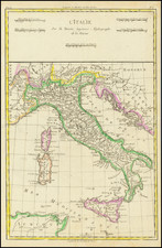
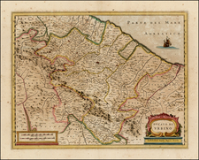
Fine large ecclesiastical map of Italy by Giacomo Rossi in Rome, based on the writings of Augustin Lubin.
The map is dedicated to Pope Innocent XII and illustrates the ecclesiastical regions of Italy in the 17th Century.
Ecclesiastical mapping refers to the process of creating maps that show the locations of religious institutions, such as churches, monasteries, and other religious buildings. They were often created by cartographers and geographers who were working for the Catholic Church or other religious institutions, and they were used to help plan the construction of new churches and other religious buildings, as well as to aid in the administration of the Catholic Church in Italy.
Augustin Lubin a French monk, was born in Paris January 29, 1624. He published many learned works on ancient and sacred geography; among others, Tabulel Sacrae Geographlica (Paris, 1670): — Martyrologium Romanum, cum tabulis geographis et notis historicis (Paris, 1660): — Tables geographiques pour les Vies des hommes illustres de Plutarque, dresses sur la traduction de l'Abbe Tallemant (Paris, 1671): — Clef du grand Pouille des Benefices de France, containing the names of the abbeys, of their founders, their situation, etc. (Paris, 1671); etc.
Giacomo Giovanni Rossi (1627-1691) was an Italian engraver and printer. He worked in Rome, the heir to an important printing business founded by his father, Giuseppe de Rossi (1570-1639). Giuseppe began the press in 1633 and Giovanni and his brother, Giandomenico (1619-1653) took it over upon his death. The brothers expanded the business and by the mid-seventeenth century it was the best-known printing house in Rome.
For his maps, Giovanni worked with Giacomo Cantelli da Vignola. They produced the Atlas Mercurio Geografico. The first edition is undated, but the second was issued in 1692, a year after Giovanni’s death. The maps were by Cantelli. The firm also published maps based on those of Nicolas Sanson.
Later, the business passed to Lorenzo Filippo (1682-?). By 1738, the firm was known as Calcografia Camerale, then, from 1870 to 1945, as the Regia Calcografica. Today, the firm is still in business and is called Calcografia Nazionale. It operates as a free museum and offers one of the best collections of prints and plates in the world.
![[Sicily] Partie Meridionale du Royaume De Naples ou se trouvent La Calabre et L'Isle et Royaume de Sicile . . . 1779 [with] Supplement pur L'Isle De Malte](https://storage.googleapis.com/raremaps/img/small/35618.jpg)