|
||

|

|
|

|
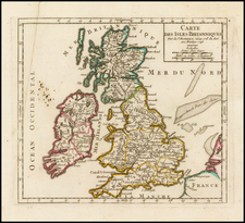
Decorative map of the British Isles, published by Carel Allard in Amsterdam.
Allard's map is a stunning and highly detailed depiction of the geography and culture of Great Britain in the late 17th century. Its intricate details and beautiful design make it a valuable historical artifact and a fascinating piece of cartographic art.
One of the most prominent features of the map is the large allegorical title cartouche, which features cherubs and a large coat of arms, framed by a lion and unicorn.
The map itself is divided into several regions, including England, Scotland, and Ireland. The coastlines are carefully delineated and include many small towns and cities, as well as some larger port cities such as London and Edinburgh.
At the top left is a large inset map of the Orkney Islands, which are located off the northern coast of Scotland. The inset map is highly detailed and includes many small islands, bays, and peninsulas.
The map would later be re-issued by Covens & Mortier.
Carel (Carol) Allard (Allardt) (1648–1709) was an engraver and publisher based in Amsterdam. Part of a prominent family of Dutch mapmakers, publishers, and print sellers, his father was engraver and publisher Hugo Allard (1627–1684), who left his business to Carel upon his death. Carel published anything in demand, including maps, topography, ethnography, newsprints, and restrikes of old plates of artistic prints, many of which likely came from his father’s stock. In 1706, Carel gave his copperplates to his son Abraham Allard, before going bankrupt.
![[ Pictish Man Holding Severed Head ] Picti icon](https://storage.googleapis.com/raremaps/img/small/99837.jpg)
![[ London & Westminster ] Midle-Sex described With The Most Famous Cities of London and Westminster](https://storage.googleapis.com/raremaps/img/small/102121.jpg)