


|
||

|

|
|

|
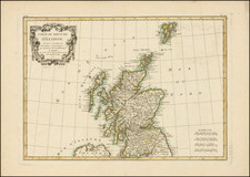
The antique map of Scotland titled "Scotia Regnum" was published in Amsterdam in the 1640s by the renowned mapmaker Jan Jansson. The map is a detailed representation of the region, including Scotland and the surrounding islands, with an inset map of the Orkney Islands in the upper right corner.
The map is notable for its detailed depiction of the topography of Scotland, including major cities and towns, rivers, and bodies of water. The cartography is highly detailed and precise, with carefully drawn coastlines and intricate details of the interior of the country.
In addition to its geographical features, the map also includes a depiction of the Royal Coat of Arms to the right of the main map. In the lower right corner is an elaborate title cartouche, which includes the map's title in Latin.
The map was published around the time of the English Civil War, and,as such, provides valuable insight into the political and cultural climate of the time. It is an important historical document and a valuable addition to any collection of antique maps of Scotland.
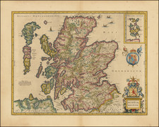
Jan Janssonius (also known as Johann or Jan Jansson or Janszoon) (1588-1664) was a renowned geographer and publisher of the seventeenth century, when the Dutch dominated map publishing in Europe. Born in Arnhem, Jan was first exposed to the trade via his father, who was also a bookseller and publisher. In 1612, Jan married the daughter of Jodocus Hondius, who was also a prominent mapmaker and seller. Jonssonius’ first maps date from 1616.
In the 1630s, Janssonius worked with his brother-in-law, Henricus Hondius. Their most successful venture was to reissue the Mercator-Hondius atlas. Jodocus Hondius had acquired the plates to the Mercator atlas, first published in 1595, and added 36 additional maps. After Hondius died in 1612, Henricus took over publication; Janssonius joined the venture in 1633. Eventually, the atlas was renamed the Atlas Novus and then the Atlas Major, by which time it had expanded to eleven volumes. Janssonius is also well known for his volume of English county maps, published in 1646.
Janssonius died in Amsterdam in 1664. His son-in-law, Johannes van Waesbergen, took over his business. Eventually, many of Janssonius’ plates were sold to Gerard Valck and Pieter Schenk, who added their names and continued to reissue the maps.
![Scotia Antiqua, qualis pricis temporibus Romanis praesertim, Cognita suit quam in lucem eruere conabatur R Gordonius a Straloch M DC LIII [Ancient Scotia, as it was known in earlier times, particularly to the Romans, attempted to be brought to light by R. Gordonius of Straloch in 1653.]](https://storage.googleapis.com/raremaps/img/small/93094.jpg)
![[ Scotland ] North Britain or Scotland Divided into its Counties Corrected from the best Surveys . . .](https://storage.googleapis.com/raremaps/img/small/102877.jpg)