|
||

|

|
|

|
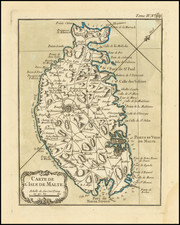
Finely colored example of Jan Jansson's double-page engraved map of Malta from his Atlas Novus, oriented southwest, with an inset of Valetta. Filfla, the most southerly point in the Maltese archipelago and shown with a watchtower, is at the top of the map, above Zurrieq.
Several warring galleys are depicted, as are many watchtowers. In a somewhat central location and near "Il bozchetto" (the Buskett Gardens or il Boschetto) is "La Cité vieille", or the old capital, Mdina. Birgu, an important port and for a time the de facto capital, is shown on the peninsula to the left of Valletta. The Knights Hospitaller reigned from 1530 to 1798; the islands were under frequent siege, particularly from the Ottoman Empire.
A wonderfully decorative map and scarce on the market.
Jan Janssonius (also known as Johann or Jan Jansson or Janszoon) (1588-1664) was a renowned geographer and publisher of the seventeenth century, when the Dutch dominated map publishing in Europe. Born in Arnhem, Jan was first exposed to the trade via his father, who was also a bookseller and publisher. In 1612, Jan married the daughter of Jodocus Hondius, who was also a prominent mapmaker and seller. Jonssonius’ first maps date from 1616.
In the 1630s, Janssonius worked with his brother-in-law, Henricus Hondius. Their most successful venture was to reissue the Mercator-Hondius atlas. Jodocus Hondius had acquired the plates to the Mercator atlas, first published in 1595, and added 36 additional maps. After Hondius died in 1612, Henricus took over publication; Janssonius joined the venture in 1633. Eventually, the atlas was renamed the Atlas Novus and then the Atlas Major, by which time it had expanded to eleven volumes. Janssonius is also well known for his volume of English county maps, published in 1646.
Janssonius died in Amsterdam in 1664. His son-in-law, Johannes van Waesbergen, took over his business. Eventually, many of Janssonius’ plates were sold to Gerard Valck and Pieter Schenk, who added their names and continued to reissue the maps.
![Valetta, the Capital of the Island of Malta [with] Balearic Islands [and] Corsica and Sardinia](https://storage.googleapis.com/raremaps/img/small/60552.jpg)
![Valetta, the Capital of the Island of Malta [with] Balearic Islands [and] Corsica and Sardinia](https://storage.googleapis.com/raremaps/img/small/87300.jpg)
![[Malta] De Melita insula. Melita insula, ab Sicilia disiuneta Africam versus s hierosolimitanor[um] militum sedes](https://storage.googleapis.com/raremaps/img/small/73753.jpg)