


|
||

|

|
|

|
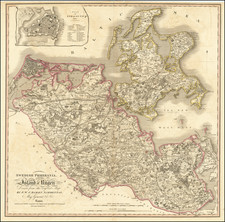
Rare German propaganda poster, showing the extensive German railroad lines connecting to the Western Front and the allied railroads destroyed during the German spring offensive of 1918.
The map shows the region between the North Sea coast and Verdun, delimiting the frontlines. Lille, Valenciennes, and Etain are absorbed into German territory. French railways destroyed by the Germans are shown in red. An inset in the upper right shows small lands gained by the French during the Some offensive in 1916 and the Flanders offensive of 1917, while grey denotes the significantly larger gains by the German army in 1918. Text below the map describes previous successful German offensives.
The grey, drab tones of the map are perfectly in line with the declining German morale in 1918.
![[France, Belgium, Switzerland and Gemany]](https://storage.googleapis.com/raremaps/img/small/75179.jpg)
![Daniae Regni Typus [with] Cimbricae Chersonese nunc Iutiae descriptio ..](https://storage.googleapis.com/raremaps/img/small/94423.jpg)
![[ Holy Roman Empire ] A New Map of the German Empire, and the Neighbouring States with their Principal Post Roads, Originally Published by the Royal Academy of Berlin . . . 1788](https://storage.googleapis.com/raremaps/img/small/102913.jpg)
![[ Lower Rhine River & Wesser River Region ] Die dritte Tafel des Rheinstroms / Innhaltend das Nider Teutschlandt](https://storage.googleapis.com/raremaps/img/small/81288.jpg)