|
||

|

|
|

|
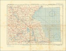
Rare Road Map of Sicily Likely Issued by US Intelligence Before the Allied Invasion.
Rare Allied Force Headquarters map of the roads of Italy, almost certainly published in the lead-up to the Allied landings on the island and the start of the western Allies' reconquest of Europe. The map is rated "For Use of War and Navy Depts Only. Not for Distribution."
The map shows the roads of Sicily alongside insets of the island's most populous cities, including Palermo, Catania, Agrigento, Messina, and Syracuse. Mileage between cities, different types of roads, and air bases are shown. A note states that some of the data is not based on reconnaissance and the reliability is uncertain. Another note states that "Officers using this map will mark hereon corrections and additions which come to their attention and forward through Engineer channels.
Operation Husky, or the July 1943 Allied landings in Sicily, was one of the major campaigns of the Second World War, which forced German troops to be redirected from the Eastern Front, effectively ending German offensive capabilities, and led to the toppling of Mussolini only two weeks after the first landings. The operation is well remembered for the diversionary tactics employed, where, during Operation Mincemeat, British intelligence convinced German troops that landings were to be made in Greece. As such, it would have been key to preserving the secrecy of plans such as these prior to the invasion.
Rarity
We locate three known examples of the map through OCLC, at the Newberry Library, Wisconsin Veteran Museum, and University of Oxford. We locate another example that has traded.
![(Second World War) Your Submarine Versatile Warship [on verso:] NEWSMAP For the Armed Forces 268th Week of the War - 150th of U.S. Participation](https://storage.googleapis.com/raremaps/img/small/95106.jpg)
![[Uniforms and Insignia of the German Army] Форма Обмундирования и Знаки Различия Германской Армии](https://storage.googleapis.com/raremaps/img/small/67803.jpg)
![(Second World War - Okinawa) [Large Battlefield Composite Map of Okinawa]](https://storage.googleapis.com/raremaps/img/small/63896.jpg)
![(World War II - Jewish Resistance in Poland) ספר מלחמות הגיטאת [Book of the Ghetto Wars]](https://storage.googleapis.com/raremaps/img/small/81013.jpg)