


|
||

|

|
|

|
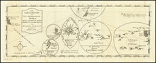
Nice example of Cook's map of Tahiti, from the Official Account of Cook's First Voyage.
Tahiti was first visited by Europeans in 1767, when it was located by the HMS Dolphin, under the command of Captain Samuel Wallis. Wallis remained in the islands near Tahiti from June 19 to July 28, 1767, during an early English circumnavigation of the globe. It is possible that Tahiti had been previously sighted by Portuguese navigator Pedro Fernandes de Queiros, serving the Spanish Crown, in 1606, but more probably that Queiros sighted La Sagitaria Island (Rekareka), to the Southeast of Tahiti.
Wallis was followed in April 1768 by the French explorer Louis Antoine de Bougainville, completing the first French circumnavigation. Bougainville made Tahiti famous in Europe when he published his Voyage autour du monde. He described the island as an earthly paradise where men and women live happily in innocence, away from the corruption of civilization. His account illustrated the concept of the noble savage, and influenced utopian thoughts of philosophers such as Jean-Jacques Rousseau before the French Revolution.
In April 1769, Captain James Cook made his first visit to the island. He, along with Charles Green and Daniel Solander, set up camp at Matavai Bay and stayed on until 9 August, 1769. On later visits Cook made harbor at Tautira Bay which is sometimes known as Cook's Anchorage.
![[Straits of Le Maire, Nova Guinea, South Pacific]](https://storage.googleapis.com/raremaps/img/small/61345op.jpg)
![[Cook's Route through New Caledonia and New Hebrides] Carta delle scoperte fatte nel mar Pacifico sopra il Vascello la Resolution, Comandata dal Capitano Cook, nel 1774](https://storage.googleapis.com/raremaps/img/small/91872.jpg)