|
||

|

|
|

|
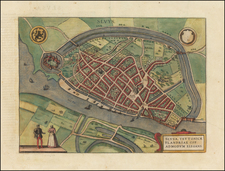
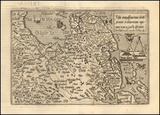
Bird's-eye views of the four Friesland cities of Sneek, Dokkum, Sloten, and IJlst. Two peasant couples, in Sloten and IJlst, are depicted humbly dressed, their ruffs still modest.
In Sneek, which has its characteristic onion shape, the Martinikerk dominates the cityscape.
Dokkum would be conquered in 1580 by Philip Count of Hohenlohe-Langenburg for William of Orange, ending the Spanish Habsburgian rule of the Eighty Years' War.
During the Eight Years' War, Sloten was the site of a failed, Trojan Horse-like attempt to sack the city by hiding men in a beer ship.
IJlst, just three kilometers from Sneek, is shown bisected by the Ee River.
All four are on the Elfstedentocht route, a long-distance tour skating event (held only if weather permitting) that visits eleven historical Friesland cities.
Georg Braun (1541-1622) was born and died in Cologne. His primary vocation was as Catholic cleric; he spent thirty-seven years as canon and dean at the church St. Maria ad Gradus, in Cologne. Braun was the chief editor of the Civitates orbis terrarum, the greatest book of town views ever published. His job entailed hiring artists, acquiring source material for the maps and views, and writing the text. In this role, he was assisted by Abraham Ortelius. Braun lived into his 80s, and he was the only member of the original team to witness the publication of the sixth volume in 1617.
Frans Hogenberg (ca. 1540-ca. 1590) was a Flemish and German engraver and mapmaker who also painted. He was born in Mechelen, south of Antwerp, the son of wood engraver and etcher Nicolas Hogenberg. Together with his father, brother (Remigius), uncle, and cousins, Frans was one member of a prominent artistic family in the Netherlands.
During the 1550s, Frans worked in Antwerp with the famous mapmaker Abraham Ortelius. There, he engraved the maps for Ortelius’ groundbreaking first atlas, published in Antwerp in 1570, along with Johannes van Deotecum and Ambrosius and Ferdinand Arsenius. It is suspected he engraved the title page as well. Later, Ortelius supported Hogenberg with information for a different project, the Civitates orbis terrarium (edited by Georg Braun, engraved by Hogenberg, published in six volumes, Cologne, 1572-1617). Hogenberg engraved the majority of the work’s 546 prospects and views.
It is possible that Frans spent some time in England while fleeing from religious persecution, but he was living and working in Cologne by 1580. That is the city where he died around 1590. In addition to his maps, he is known for his historical allegories and portraits. His brother, Remigius, also went on to some fame as an engraver, and he died around the same time as his brother.
![[Gelderland and Overijssel] Geldria et Transysulana](https://storage.googleapis.com/raremaps/img/small/80582.jpg)