|
||

|

|
|

|
Gerardus Mercator is a name synonymous with modern cartography. His pioneering approach to navigation charts and the projection that carries his name have made him a titan in the history of map-making. However, an intriguing aspect of his work, often overshadowed by his innovative contributions, was his deep fascination with the ancient geographer, Claudius Ptolemy. This admiration led him to publish his own version of Ptolemy's Geographia, which included a remarkable Ptolemaic map of the Holy Land, Cyprus, Syria, and surrounding regions.
Gerardus Mercator, born in 1512 in the Duchy of Jülich (modern-day Belgium), was a cartographer, philosopher, and mathematician. His greatest contribution to cartography was the Mercator Projection, a navigational tool that revolutionized sea travel during the Age of Exploration. It represents the globe as a flat surface while maintaining true compass bearings, enabling sailors to plot straight-line courses despite the distortion of size towards the poles.
Claudius Ptolemy, a Greco-Roman mathematician, astronomer, and geographer of the 2nd Century CE, authored the Geographia, a treatise providing the theoretical basis for cartography and including detailed instructions for drawing maps of the entire known world. Despite its inaccuracies by modern standards, it held immense value for the Renaissance thinkers who rediscovered it in the 14th century. Ptolemy's work sparked a renewed interest in geography and initiated an era of intense map-making in Europe.
Mercator was one of the Renaissance scholars deeply influenced by Ptolemy's Geographia. His interest in Ptolemy's work was twofold. Firstly, he acknowledged Ptolemy as the foundational figure in geography, whose systematic approach to mapping the known world had been unmatched for over a thousand years. Secondly, Mercator viewed Ptolemy’s work as a window into the knowledge of the ancient world, which he believed needed preservation.
In 1578, Mercator published his own version of Ptolemy's Geographia. This edition was an amalgamation of ancient wisdom and Renaissance craftsmanship, which displayed not only Ptolemy's original 2nd-century world view but also showcased the advanced engraving techniques and meticulous details that Mercator was known for.
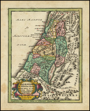
The map of the Holy Land, Cyprus, and Syria is an exemplar of this synergy. Mercator recreated Ptolemy's conception of these regions while introducing the finesse and precision of his own cartographic style. The map features the regions as they were understood in the ancient world, with the Jordan River, Dead Sea, Mediterranean coast, and prominent cities like Jerusalem and Antioch clearly depicted. Similarly, the island of Cyprus, an important location in ancient Mediterranean trade routes, and Syria, the crossroads of several ancient civilizations, are also intricately detailed.
While faithful to Ptolemy's representation, the map is unmistakably a Mercator artifact. It boasts intricate details, clear engravings, and a systematic grid, all hallmarks of Mercator's work. Furthermore, the map includes his own modifications based on more recent geographical discoveries, subtly integrating Ptolemaic tradition and modern knowledge.
Gerard Mercator is one of the most famous cartographers of all time. Mercator was born in Flanders and educated at the Catholic University in Leuven. After his graduation in 1532, Mercator worked with Gemma Frisius, a prominent mathematician, and Gaspar a Myrica, a goldsmith and engraver. Together, these men produced globes and scientific instruments, allowing Mercator to hone his skills.
With his wife, Barbara, Mercator had six children: Arnold, Emerentia, Dorothes, Bartholomeus, Rumold, and Catharina. In 1552, Mercator moved to Duisburg from Leuven, where he lived for the rest of his life. In 1564, he was appointed the official cosmographer to the court of Duke Wilhelm of Cleve.
Mercator’s most important contribution was the creation and popularization of a projection which now bears his name. On Mercator projection maps, all parallels and meridians are drawn at right angles to each other, with the distance between the parallels extending towards the poles. This allowed for accurate latitude and longitude calculation and also allowed navigational routes to be drawn using straight lines, a huge advantage for sailors as this allowed them to plot courses without constant recourse to adjusting compass readings.
Mercator’s other enduring contribution to cartography is the term “atlas”, which was first used to describe his collection of maps gathered in one volume. The Mercator atlas was published in 1595, a year after Mercator’s death, thanks to the work of his sons, particularly Rumold, and his grandsons.
![Carte De La Syrie [Shows Cyprus and the Holy Land!]](https://storage.googleapis.com/raremaps/img/small/61321.jpg)
![[ Gifted To Cecil B. De Mille by Elmer Bernstein ] (Mortier Bible) Histoire du Vieux et du Nouveau Testament Enrichie de plus de quatre cens Figures En Taille-Douce, &c. [2 vols in 1]](https://storage.googleapis.com/raremaps/img/small/96625.jpg)