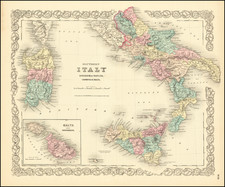
|
||

|

|
|

|
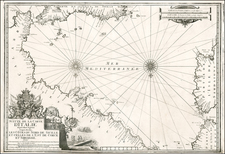
Fine example of Mercator's map of the central Mediterranean, showing the islands of Sicily, Sardinia, and Corsica, as well as part of the Calabrian mainland. This map first appeared in Munster's Geographia, and shows a remarkable depiction of the region as it was known in Ptolemy's time.
Mt. Aetna is shown erupting on the island of Sicily. A striking scene of a major naval battle is shown below Sardinia. Several cities, mountain ranges, and rivers are shown, and many small islands are named. Sea monsters can be found throughout.
This example of the map is from a later edition of Mercator's atlas and includes a cartouche updated to reflect late 16th-century sensibilities.
Münster's 1540 Geographia deserves a number of superlatives. First, it established the convention that a world atlas should include world and continental maps. To that end, it was the first atlas to include specific maps of the Americas, Europe, Africa, and Asia. This change was in no small part influenced by the first circumnavigation of the globe by Ferdinand Magellan in 1522. The Geographia was the first printed work to render latitude and longitude in their now-standard degree-minute-second form. And it was the book that ushered in a series of "modern"-style world atlases culminating in the 1570 Theatrum Orbis Terrarum of Abraham Ortelius.
Gerard Mercator is one of the most famous cartographers of all time. Mercator was born in Flanders and educated at the Catholic University in Leuven. After his graduation in 1532, Mercator worked with Gemma Frisius, a prominent mathematician, and Gaspar a Myrica, a goldsmith and engraver. Together, these men produced globes and scientific instruments, allowing Mercator to hone his skills.
With his wife, Barbara, Mercator had six children: Arnold, Emerentia, Dorothes, Bartholomeus, Rumold, and Catharina. In 1552, Mercator moved to Duisburg from Leuven, where he lived for the rest of his life. In 1564, he was appointed the official cosmographer to the court of Duke Wilhelm of Cleve.
Mercator’s most important contribution was the creation and popularization of a projection which now bears his name. On Mercator projection maps, all parallels and meridians are drawn at right angles to each other, with the distance between the parallels extending towards the poles. This allowed for accurate latitude and longitude calculation and also allowed navigational routes to be drawn using straight lines, a huge advantage for sailors as this allowed them to plot courses without constant recourse to adjusting compass readings.
Mercator’s other enduring contribution to cartography is the term “atlas”, which was first used to describe his collection of maps gathered in one volume. The Mercator atlas was published in 1595, a year after Mercator’s death, thanks to the work of his sons, particularly Rumold, and his grandsons.
![Elba [and] Sicilia](https://storage.googleapis.com/raremaps/img/small/66222.jpg)
![Tabula Aphricae II [shows Sicily and Sardinia]](https://storage.googleapis.com/raremaps/img/small/47363.jpg)