|
||

|

|
|

|
Antique map of Mexico with the diagram of elevation of vegetation from Antonio Garcia Cubas' "Carta Agricola" from his Atlas pintoresco.
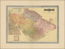
This map Territorio de Tepic, a territory created in 1884 out of the northwestern part of Jalisco, before it became the state of Nayarit in 1917. The Mexican Railway line from Veracruz to Mexico City is shown, but the link to Salina Cruz, on the Pacific Coast, had not yet been completed. Ciudad Juarez, known as Paso del Norte until it was renamed in 1888 to honor Benito Juarez, is linked to Mexico City by the Mexican Central Railway. Between Guadalajara and Irapuato, a dashed line shows a connection to this main artery that would be completed in 1888. In that same year, Baja California would be split into a northern and southern state; here it is a single territory with its northern capital in Santo Tomás, today a town in Ensenada Municipality (whose port is labeled "Pto de Todos Santos"), central capital in Comondu, and southern capital in La Paz. Delineated in red are telegraph lines.
![(Texas Mexico Borderlands) [Map of the Rio Grande, Texas - Mexico border, from the Big Bend to the town of Mier] Copiado del Mapa de S. Mc. L. Staples, 1828... Dibujado y extractado de los documentos y datos dichos, por F. L. Mier - Monterey, Diciembre de 1873.](https://storage.googleapis.com/raremaps/img/small/91667.jpg)
![[ The Silver Route -- Mexico City to Santa Fe, New Mexico ] Carte de la Route qui mene depuis la Capitale de la Nouvelle Espagne jusqu'a S. Fe. du Nouveau Mexique Dressee sur les Journaux de Don Pedro de Rivera et en partie sur les Observations Astronomique de Mr. de Humboldt.](https://storage.googleapis.com/raremaps/img/small/102164.jpg)