|
||

|

|
|

|
The City of New York Sells the Southern Tip of Manhattan Into Private Hands.
The 1732 Sale of Battery-Adjacent Waterfront Land to Manhattan's Leading Citizens.
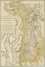
Exceptional plat map of the land sold by the Corporation of New York to Robert Livingston Junior, Stephen Delancey, Anthony Rutgers, and John Moore shortly after the Montgomerie Charter confirmed the ability of the City to sell common waterfront land.
The map shows the Battery at the bottom of the map, at the far west. Above this is Whitehall Slip, an old slip used for loading boats and now covered by Whitehall Street. Next are the eight lots in question, split by the unnamed Water Street. At the top of the map, across from what is now known as Moore Street, is the "West Dock" and various city wharves extending into the East River. This layout can be seen on the circa 1755 Maerschalck map of Lower Manhattan, which is nearly identical in geography save that the later plat shows the extensions of wharves adjacent to Moore's and Rutger's lots. Today, the two blocks shown comprise New York Plaza between Pearl Street, Whitehall Street, Moore Street, and South Street
The sale of the property on the map was undertaken by the Corporation of New York in 1732, as recorded on a 1772 plat map held with the Bancker Plans of the NYPL. That map shows the northern four lots (above Water Street) as well as three lots further inland not on the present map. At the top of the map in the NYPL is a declaration that it is a:
Copy of a Map (in the Town Clerk's Office) of the White Hall Lots as they were sold by the Corporation in the Year 1732. And from the Record, I find this was granted to Mrs. Moore, Delancey, Livingstone, & Rutgers 200 feet from the customs house out into the East River and the Breadth of 31 1/2 feet from it as well as rear to each of them. . .
The Montgomerie Charter and the Transfer of Private Land
The sale of the land shown on the map is intrinsically tied to the issuance of the Montgomerie Charter in 1731. Teaford, in The Birth of a Public Corporation, describes the impact of the charter as follows:
Granted by Governor Montgomerie as representative of the Crown, this charter bestowed ample property on the corporation of the city of New York. It confirmed the corporation's valuable East River ferry monopoly and its ownership of all the common and wastelands on Manhattan Island, both of these privileges originally having been granted in earlier charters. In addition, it bestowed on the corporation ownership of all submerged lands around the southern part of Manhattan Island up to four hundred feet beyond the low water mark.
As shown by the sale of this land in 1732, it appears that the city immediately began selling some choice plots by auction.
The Montgomerie Charter was intrinsic to the growth of New York City as it consolidated the corporate nature of the city government. It forced the government to rely on land sales and rent derived from its property holdings rather than taxation for its income. While there is copious evidence that this led to some corrupt practices, the retention of significant portions of waterfront property (the present lots excluded) allowed the city to dictate its growth into the position of one of the world's wealthiest cities over the next century.
Landowners Named
The proprietors named on the map are:
- Stephen Delancey (1663 - 1741), city Alderman and donor of Manhattan's first fire engine and town clock. He possessed large amounts of land in New York City and was one of its wealthiest inhabitants. In 1719, he moved into a three-story house on Pearl Street, now the Fraunces Tavern. In the 1730s, he moved to a mansion near Trinity Church.
- Robert Livingston Junior, this appears to be Robert Livingston (1708 - 1790), U.S. Secretary of Foreign affairs from 1781 to 1783. He was the grandson of Robert Livingston the Elder (1654 - 1728) and nephew of Robert Livingston the Younger (1663 - 1725). In 1740, he would inherit the title "Lord of Livingston Manor" and with it vast swaths of land in the Hudson Valley and Albany areas. The title would die with him in 1790. He is less commonly referred to as Robert Livingston Jr., but the title was evidently applied to him in some official documents.
- John Moore (1686 - 1749), apprentice to Stephen Delancey and later business partner. In 1716, he is listed as co-owner of the trading vessel Elizabeth with Stephen DeLancey. He was later elected an alderman and held several other positions of power. However, his refusal to observe mourning for Queen Caroline led to his nomination for Councilor to the Lords of Trade being withdrawn.
- Anthony Rutgers (c. 1675 - c. 1746), relative of war hero and philanthropist Henry Rutgers. Of the four landowners, the least is known about Rutgers. His significant achievement appears to be the draining of the swamp surrounding Collect Pond in 1733 via a ditch to the Hudson River, which would evolve into a canal and give its name to Canal Street.
Dating the Plat
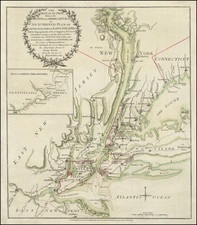
The geography shown on the map is an intermediary between the 1730 Bradford plan, which does not show the lots in question, and the circa 1755 Maerschalck map of Lower Manhattan, which shows the lots fully developed with wharves on both sides of the plots.
This map shows only a stunted Moore's wharf, with the note:
JM Wharf 96 Foot as now Made.
To the north is the "City Wharf," which appears on the aforementioned Bradford map.
Development of the Lots in the Pre-Revolutionary Period
The sale of the inland lots are noted in David Valentine's 1853 History of the City of New York:
On the opposite side of Whitehall street, in the block bounded, at present, by Whitehall, Pearl, Moore and Water streets, there had, previous to the year 1730, been an open space, anciently called " The Strand," and commonly used as a market place or strand for country wagons. In 1732, the city corporation divided the ground into lots, and sold it at auction, as follows: Three lots to Stephen Delancey for six hundred pounds; one to David Clarkson for one hundred and fifty-six pounds; one to John Moore for two hundred and seventy-six pounds; one to Robert Livingston for one hundred and seventy-five pounds, and one to Anthony Rutgers for two hundred and thirty-nine pounds.
The seven lots referenced by David Valentine include the four inland lots on the present map and three lots lying just off the northern edge of the map. The sale of the four waterfront lots also included land into the East River, as noted in the above quote from the 1772 Livingston plat, restated here:
I find this was granted to Mrs. Moore, Delancey, Livingstone, & Rutgers 200 feet from the customs house out into the East River.
This map shows that 200-foot extension into the East River.
Provenance
We acquired this map and a cache of other Livingston family documents (many from the 18th century) in the fall of 2022.
The Birth of a Public Corporation. Jon C. Teaford. 1985.