


|
||

|

|
|

|
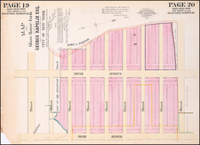
Revolutionary- or Early Federal-Period Plat of Land in New York City Owned by the Livingston Family.
Set of two plat maps, on one sheet, one showing the block bounded by Attorney Street, Rivington Street, Delancey Street, and Arundel (now Clinton) Street; the other showing the block bounded by Delancey Street, Pitt, Street, Ridge Street, and Broome Street in Manhattan's Lower East Side.
The map shows the land owned by the four Livingston brothers, Henry (1752-1823), Robert C. (1751-1794), John (1749-1822), and Walter (1740-1797). The death of Robert C, in 1794, provides the latest date at which the plat could have been made.
On the map, the four brothers are shown owning the whole of the right city block and half of the left city block. These blocks are, for the most part, marked according to initials. Robert C. Livingston's land is clearly marked "R. C. L.". Henry Livingston's land is sometimes marked "H. L.", sometimes "I. L.", with a cross for the H penciled in. Walter's land appears to be lots 15-22 along Delancey Street and lots 25-28 along Attorney Street, his "W. L.," is somewhat hard to distinguish from an H but clearly has more curvature and can be discerned through comparison. John Livingston's land is unclearly marked, but, by elimination, it must be represented as the lots marked "P. S. L."
The Livingston Family
The four brothers mentioned on the map were the scions of the Livingston family, one of the most prominent families in Colonial America. Robert Livingston the Elder (1654-1728), a prominent fur trader and merchant, was granted Livingston Manor in New York's Hudson River Valley in 1715, which was accompanied by huge swaths of land and enormous prestige. The manor passed through his family for several generations before reaching Robert Livingston (1708-1790), father of the four brothers mentioned here and the last Lord of Livingston Manor.
During the American Revolution, Livingston family members were heavily involved in the war effort. Livingstons included a drafter and several signers of the Declaration of Independence, the first Secretary of Foreign affairs, and the first Governor of New Jersey.
Bancker Surveys of New York
The verso of the map states that it was "Copied by R. P. L. from Bancker's map." In addition, pencil manuscript on the front of the map references "Bancker's Hudson Sheets for the Original Surveys." The Bancker brothers, Gerard (1740-1799) and Evert (1734-1815) were important New York City Surveyors active during the period 1770 to 1810. Most of the plans "date from just before, during, and after the Revolutionary period" (NYPL). Many of the Bancker plats and plans are today held by the New York Public Library.
"R. P. L"
Given the importance and prevalence of the name "Robert Livingston" during the Revolutionary War, it is very likely that R. P. L. refers to Robert P. Livingston, more commonly (and confusingly) known as Robert R. Livingston or Robert Lucian Livingston. This Livingston is most famous as a member of the Committee of Five and for administering the Presidential Oath of Office for George Washington. He also served as Recorder of New York City in 1773, which indicates that he had the skillset and knowledge necessary to create such a plat.
While Livingston's name appears more commonly as "Robert R. Livingston," there are numerous sources that also cite him as Robert P. Livingston, most notably his records in Freemasonry contexts, with which he was deeply involved.
![[Brooklyn] Manhattan Beach Estates - Map of Property situated in the Borough of Brooklyn](https://storage.googleapis.com/raremaps/img/small/80730.jpg)
![[Hells Kitchen / Midtown West] Map of the Hermitage Farm and the Norton Estate Compiled From Authentic Data.](https://storage.googleapis.com/raremaps/img/small/61035.jpg)