The item illustrated and described below is sold, but we
have another example in stock. To view the example which
is currently being offered for sale, click the
"View Details" button below.


|
||

|

|
|

|
Stock# 88939
Description
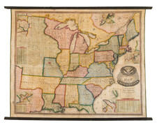
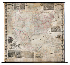
Early Appearance of Dallas!
A gorgeous example of Flemming's four-sheet map of the United States, published in Glogau circa 1850.
The map includes a fine image of the early United States territorial borders, Indian Districts, forts, early routes of the Transmississippi explorers, and other details.
Many Indian tribes, forts, missions, roads, and other details are shown.
Includes a very unusual tomahawk-shaped Indian Territory and massive Minnesota, Nebraska, and Missouri Territories. New Mexico and Arizona are joined, and Utah is in a State of Deseret configuration. The map includes, intriguingly, an inset of the Galapagos.
One of the great pre-Gadsden Purchase atlas maps.
Condition Description
Two stone lithograph supplemented with original hand-color, in outline. Four sheets, unjoined.