


|
||

|

|
|

|
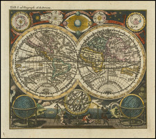
Fine image of the world map from the Rome edition of the Ptolemy, issued by Harper's Weekly for their November 17, 1877 edition.
The Rome Ptolemy world map is the fourth printed world map, and was first issued in 1478. It is preceded by the 1477 Bologna edition of Ptolemy's work. This example of the map was copied (in the 19th century) from the example of the Rome Ptolemy healed by the American Geographical Society.
The Ptolemaic world map is based on the writings of Claudius Ptolemy, a second century mathematician who wrote down coordinates for all of the known cities and geographical features in the world. While some parts of the map are accurate, such as the Mediterranean, other parts are more conjectural, such as Africa, Sri Lanka (Taprobana Insula) and Southeast Asia. Of course, none of the Americas are shown.
![[ Volcanic Regions ] Geografia Dei Vulcani Accesi Ed Estinti](https://storage.googleapis.com/raremaps/img/small/101861.jpg)
