


|
||

|

|
|

|
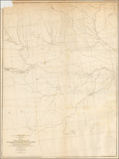
Nice example of Fremont’s map of the area between North Platte, Nebraska to the Rocky Mountains and Wind River Mountains of today's south east Wyoming and northeastern Colorado.
From 1842 to 1846, Join Fremont led 3 expeditions of the west with Kit Carson as guide. These explorations include establishing the route which would become known as the Oregon Trail, the first major overland route to the West Coast. He was the first American to see Lake Tahoe and established that the Great Basin of Utah and Nevada had no direct river to the Pacific.
The present map covers a large part of Fremont's first expedition to the Rockies in 1842, locating the Medicine Bow Mountains, New Park Mountains, Wind River Mountains, the Laramie Plains, and St. Vrain's Fort. Fremont surveyed the Oregon Trail as far as South Pass and then explored the Wind River Range of the Rocky Mountains. Wheat describes the maps from his expedition as "a highly creditable production" that is free of "imaginary geography."
![[ Western United States -- Massive Idaho Territory ]](https://storage.googleapis.com/raremaps/img/small/99057.jpg)
![[ Jackson Hole and Environs ] Geological Map of Portions of Wyoming, Idaho and Utah](https://storage.googleapis.com/raremaps/img/small/97191.jpg)
![[DeWitt Clinton Copy] An Account of Expeditions to the Sources of the Mississippi, and through the Western Parts of Louisiana, to the Sources of the Arkansaw, Kans, La Platte, and Pierre Jaun, Rivers During the years 1805, 1806 and 1807. And a Tour through the Interior Parts of New Spain. in the year 1807.](https://storage.googleapis.com/raremaps/img/small/81745.jpg)